From Sheridan — well, actually from Twin Bridges, the next little town down the road — there were two ways to go. One north, which I hadn’t driven before but which led to I-90, which I’ve driven at least a couple dozen times, and one southwest towards I-15, that stretch of which I’d never driven before. Even though it was about twenty miles further, guess which way I took?
And I’m glad I did. The first bit was very pretty, through sparsely populated ranch land ringed with mountains and down into the town of Dillon on I-15. I’ve only been to Dillon once before. It was the first place on my Long Trip in which I couldn’t find a place to stay (due to it being Labor Day and the annual rodeo).
From Dillon I headed north on I-15, and, less than twenty miles down the road, I happened to glance over to the right and saw a bald eagle perched on one of the posts holding up the wire fence running alongside the road. Fully mature, white head and all, he had to be two feet tall, I swear. Too bad I was going 70 mph on a freeway — I’d have tried to take a picture of him. He was amazing.
Deer Lodge Pass over the Continental Divide south of Butte (where I-15 and I-90 cross) is much more gradual and less steep than Homestake Pass due west of Butte. But because of that I think I was climbing pretty much all the way from Dillon to the pass. At any rate, once I hit I-90 I was on familiar territory and pretty much ready to head home.
I stopped for iced tea in Deer Lodge (the town, not the pass, which is about forty-five minutes from Butte (the highway signs say west, but the road runs almost due north-south at that point). I stopped for lunch and more gas in Missoula.
And I crossed over Lookout Pass into Idaho and the Pacific Time Zone about the middle of the afternoon, aiming for Spokane.
I won’t bore you with the hunt I had to make for a motel room in Spokane. Suffice to say that I think I’ve found a new reasonably-priced convenient place to stay there on my way to wherever, which is a good thing as the one I was used to using had upped its price out of reason because of Hoopfest (I’m assuming) that weekend.
Only one photo today, taken along I-90 between Missoula and Lookout Pass, probably closer to Lookout Pass. I was trying to take a photo of the rain falling ahead of me, which actually turned out to be mostly virga (that is, not hitting the ground).
Stormy weather along I-90 in western Montana.
And that was the penultimate day of my trip, two weeks ago today.
Okay. I downloaded the Kindle app to my Windows 8 computer some time ago. I have the tile on my start screen to prove it. But the app seems permanently and inextricably linked to only one book, and it won't let me open any other books with it! I can't even get to a menu of the books I theoretically have available.
I need to be able to open a particular reference book on my desktop so that I can refer to it easily without having to use my Kindle.
Help??? Please??? I've tried to figure it out on my own, but it just won't work.
Yes, I could use Calibre (if I could figure out how to get the book *to* Calibre -- but when I try to open the book file, it doesn't give me Calibre as an option), but at this stage of the game? It's the principle of the thing. I should be in charge of my computer, not the other way round.
Katrina? Obi-Wan? You're my only hope [wry g].
ETA: No, I can't use Calibre. The damned book is DRM'd.
ETA the 2nd Ha! Joycemocha over on LJ said, click in the middle of the screen and three lines will appear in the upper lefthand corner. If I then click on *that*, I get my list of books!!! Boy, do I feel *stupid*. Thank you, Joycemocha!!!
Sometimes traveling at the last minute just doesn’t work out. But then sometimes it does.
So. I was supposed to switch from hostel bunk to single room two weeks ago this morning. I had been informed when I originally made the reservation that the rate of $95 would include an ensuite bathroom. I was informed this morning that it was one of the rooms in the old building that shared the same bathroom as the hostel.
You have to understand. I’ve stayed in one of those rooms before (about seven or eight years ago, when they cost what a hostel bunk costs now). It wasn’t worth what I paid for it then, for two reasons. One, the room had a horrible bedbug infestation (the bunks have always been clean), and two, that’s where I had a really frightening experience with what I’m pretty darned sure was — well, I’m not going into that here. Let’s just say that the only reason I was willing to pay $95 for a room was because I thought they were going to put me in the new part of the building. The new owner and I went round and round about it, and I ended up having him refund my credit card.
But now I didn’t have a place to stay tonight, nor did I want to waste the day looking for one. So I drove back into the park figuring I’d make the best of whatever time I had left, and I’d head on out this afternoon to find somewhere to stay farther from the park before heading home tomorrow a little earlier than planned.
Which all turned out to be a good thing. At least timing-wise this morning. I headed back out into the park, towards the geyser basins again, and decided my first stop on this cloudy-but-not-raining-yet morning would be at the Fountain Paint Pots.
The Fountain Paint Pots. This early in the year, they’re kind of runny.
The Fountain Paint Pots (and the long-gone Fountain Hotel, which was nearby) are named after Fountain Geyser, which is just off the boardwalk there. It was a geyser I’d always wanted to see, but it’s not officially-predicted, and I didn’t know then about the unofficial predictions, so I’d never seen it.
So what do you think happened? Yup. Just as I walked up, it boiled over and started erupting. And if I hadn’t ended up wasting the time arguing with the owner of the Madison Hotel this morning, I’d probably have missed it — again.
Glorious, glorious Fountain Geyser, which is much taller than it looks in this photo.
As for those unofficial predictions, just as Fountain was beginning to wind down from its glorious half-hour long eruption, a very nice lady named Maureen, who turned out to be on the Geyser Gazers Facebook group, strolled over and we struck up a conversation. And she told me about the unofficial predictions available if you have a smartphone. I really do need to get a smartphone…
The rest of the morning was still wonderful, if a bit anticlimactic. I mean, there’s nothing better than a new major geyser to add to one’s life list. But I stopped at all the usual suspects that I hadn’t wanted to get soaked over before — Midway, with the clouds of steam hanging over Excelsior and Grand Prismatic.
Runoff looking back towards Grand Prismatic Spring.
Biscuit Basin, with its glorious Sapphire Pool.
Biscuit Basin’s Sapphire Pool, which erupted in 1959 after the earthquake.
And Black Sand Basin, with Cliff Geyser, which is James’s geyser. The one where he finally found out where he really came from, in a brief timeslip one sunny October afternoon in 1959/1983 in Finding Home.
James’s Cliff Geyser and hot spring runoff into Iron Creek.
By then I was way overdue for a late lunch, so I waved farewell to my favorite place on the planet once more, already making plans for a hopefully longer visit next year, and stopped in West for KFC, where the manager was having her Chinese employee write something to do with the Fourth of July on the window in Chinese characters, for some reason.
Want some Chinese fried chicken for the Fourth of July?
I then headed northwest on U.S. 287 towards Earthquake Lake, which is, obviously, the site of the earthquake I mentioned yesterday that was part of Chuck’s time travel device in Repeating History. On August 17, 1959, a 7.3-7.8 (estimates vary) earthquake struck here and an entire mountainside fell, blocking the Madison River and burying a campground, killing twenty-eight people. The quake also did a lot of damage in Yellowstone, just a few miles east of the epicenter, and, incidentally, sent my hero Chuck eighty-two years back in time.
Today it looks very peaceful, although the slide is still strongly evident fifty-five years later, and there’s an interesting, recently redone visitor center, too.
The landslide triggered by the Hebgen Lake Earthquake, which created a new lake, and, unfortunately, killed 28 people in the process.
By the time I got that far, it was midafternoon, and while I had a good idea of where I wanted to spend the night, I needed to get moving again. I drove down the Madison River valley and turned west on Montana 287 (as opposed to U.S. 287) at the town of Ennis.
The Madison River Valley south of Ennis. You’ll note that the weather improved drastically as soon as I left the Park .
I wanted to see Virginia City again. Virginia City, and the neighboring ghost town of Nevada City, are two of Montana’s earliest settlements, and I hadn’t been there since my Long Trip fifteen years ago. It’s a fun, touristy place with an interesting history as a mining camp (of course) where vigilantes dealt with the infamous Plummer Gang. Lots of false-front buildings and even a stagecoach offering rides, and plenty of historical markers. I spent a rather pleasurable hour or so there, before I climbed back in the car one last time for the day.
Boardwalks of another kind, at Virginia City, Montana.Charley hated detachable collars like the one in this Virginia City storefront.Want a stagecoach ride, little girl?
On my Long Trip (as documented in Cross-Country), I was desperate for a place to stay one night in this part of the world when I finally ran across the tiny town of Sheridan, Montana, and found a nice little place called the Moriah Motel. I was banking on it still being there, and it was. I think the same elderly lady was running it, too. It was reasonably priced and modern and that was all I needed.
So some things do work out okay. But if a friend and I do go back to Yellowstone as part of our WorldCon jaunt next year, we’re going to make our reservations in January.
Yes, I woke up to more rain two weeks ago today. I drove back into the park, anyway, of course (it’s about thirty miles from West Yellowstone to Old Faithful), and parked Kestrel (my car) near the lodge. Still feeling optimistic about the weather at this point, I packed up my daypack with all the necessities for a day out in the geyser basin, including, but not limited to, my Kindle, my journal, and my cross-stitch (some geysers must be waited for, sometimes for up to three or four hours).
Fortunately, my daypack is waterproof and I have a good raincoat. My first stop was in the visitor center, to check the eruption predictions. Old Faithful itself goes off often enough that one can often catch it in passing while headed somewhere else, but Riverside only goes off every six hours or so, Castle every nine to eleven hours, and the Grand, that pinnacle of predictible geysers, erupts about every seven to eight hours, so if I wanted to see them, I needed to know when to go sit and wait for them.
Eruption predictions are never on the minute. Grand, for instance, has a three-hour window, which means that it’s most likely to go off up to an hour and a half on either side of the prediction time. Riverside and Castle were predicted to have morning eruptions, and the Grand wasn’t due to go off till late afternoon.
Anyway. About the time I left the visitor center, the sky opened up. Not quite raining in sheets, but in the five minutes it took me to walk from the visitor center to the Old Faithful Inn, I was fairly drenched where my raincoat didn’t cover me, and the visor of my hood was dripping.
Still, as I peered through the murk over towards Old Faithful, I did see Lion Geyser erupting in the distance. But I really didn’t want to get any wetter, so I used the zoom on my camera to get this shot.
The sign says Old Faithful. The actual geyser in the distance is Lion.
And instead of sitting out in the rain waiting for things to erupt, I went into the Inn and found myself a cozy spot and caught my journal up after several days of ignoring it. Not exactly what I’d had in mind, but there are much worse places to be stranded.
The 85-foot-tall, 500-ton (according to Wikipedia, at least), four-sided fireplace in the Old Faithful Inn, with its hand-forged clock.
An hour or so later the rain let up and I finally went out into the geyser basin. I walked out as far as Castle Geyser, which had apparently gone off during the rainstorm but was still bellowing (and I mean bellowing — the sound is pretty impressive) steam.
Castle Geyser, bellowing steam in the distance.
I turned right and headed across the bridge towards Sawmill, which was churning away as usual. I know the “real” geyser gazers don’t think much of Sawmill because it robs energy and water from other, rarer geysers like Tardy and Penta, but I like Sawmill, for its chugging sound (hence the name) and simply because it looks like it’s thoroughly enjoying itself.
Sawmill Geyser on the left, and what can only be Tardy Geyser on the right, unless I’m mistaken, which is altogether possible.
Most geysers do. I can’t help anthropomorphizing them that way. I just can’t. I’ve never met a more cheerful geologic phenomenon than a geyser, and that’s just the way it is.
A view of Geyser Hill from the old road.
I strolled around Geyser Hill, past Giantess (one of the biggest geysers in the world — and also one that I’ll probably never get to see because it erupts so seldom) and Beehive, which is not an officially-predicted geyser, but can be caught occasionally because it’s got what’s called an indicator, which is a small geyser off to its side that often starts erupting just before Beehive itself does. I’d missed it this morning, but here’s what it looks like from 2008, in much better weather, when I didn’t miss it.
Beehive Geyser, 2008, from the viewpoint across the river. Note the tiny people on the boardwalk next to it.
Then it started raining again, and it was past lunchtime, so I went to what’s affectionately known as the Lower Ham (Hamilton, although it’s no longer owned by the family) store, and ate lunch at the counter there. That lunch counter/soda fountain has been there a long time, by local standards. The store itself was first built in 1897, and Charley, who was still Chuck at that point, ate his last meal in 1959 there before he inadvertently time-traveled back to 1877 in Repeating History. It’s also where James first went looking for his son just after Chuck disappeared and met Jo in Finding Home. An important place, the Lower Ham store.
This isn’t my photo, but I wanted you to see what it looks like.
Then again, so is the whole Upper Geyser Basin, so far as I’m concerned. My short story “Homesick” takes place here, too, and one geyser in particular is very significant in both Repeating Historyand “Homesick.”
My only eruption of Old Faithful on this trip, taken from the shelter of the Lodge porch.A blue bird (not sure of exact species — ETA, my birder friend Katrina says it’s a mountain bluebird) which was hanging around Old Faithful just before the eruption. The rain started again a few minutes before the geyser went off.
It took the rain a while to let back up again, alas, although I did catch what turned out to be my only view of Old Faithful from where I’d walked back to the Lodge (as opposed to the Inn), and by the time it did, it was getting close to four in the afternoon, Grand’s predicted time. Of course, given the window, it could have already gone off, but I didn’t have anything to lose except the time and a little shoe leather, so I headed back out one more time. Except for the rain, this was a pretty normal geyser basin day for me. Out and back and out and back, watch this geyser and that, have a thoroughly good time.
Anyway, when I got back out to the Grand, there were still a fair number of people sitting and waiting. My spirits rose. And, lo and behold, less than ten minutes after I sat down, guess what happened?! Grand’s pool, which had already been overflowing, started generating little waves, Turban (a kinda sorta indicator) went off, and away Grand went! I think that’s the shortest amount of time I’ve ever waited for the Grand.
This is my alltime favorite photo of the Grand, taken in 1999 during the eruption that inspired Repeating History.
And it was. Grand, that is. Just one burst, but it was a good long one, and that was enough to make my day. Make my trip, actually.
Especially since I always think of the Grand as Charley’s geyser. It was a crucial half (the other half being an earthquake I’ll tell you about tomorrow) of the phenomenon that sent Chuck back in time to become Charley in Repeating History, and it also caused Charley’s son Will and — okay, this may get confusing — Will’s five-year-old grandson Chuck (yes, that Chuck) to witness something in “Homesick” that changed their lives forever.
The rain didn’t start back up yet again until I was back in my car and headed back to West Yellowstone an hour or so later, either, and that was a good thing, too.
Rain, rain, go away. There *are* mountains there, honest.
The temperature had dropped by about twenty degrees, which was lovely, but it was pouring rain, which was very much not.
I packed up from the very nice hostel at Teton Village and headed north, anyway. What else was I going to do? It did gradually clear up the farther north I went, and by the time I reached the part of the Tetons I’d been to before, the clouds were beginning to let those sharp, pointy mountains shred them a bit. (You do know what “tetons” means in French, right? — those fur trappers must have been out there a long time to make that particular association), and by the time I reached the southern entrance to Yellowstone, it had pretty much stopped raining, thankyouverymuch, although it was still nice and cool.
See, mountains! Shredding clouds, too.
I’d never approached Yellowstone from the south before. Because of where I live, I usually come at it through either the north or the west entrance. I missed out on entering via the northeast entrance two years ago because the Beartooth Highway (which tops out at almost 11,000 feet) was still blocked by snow in June. Anyway, it was an interesting change, and one that required me to show my parks pass three times today — once entering Grand Teton NP via the same goat trail I’d taken the day before, once re-entering GTNP via the Moran entrance (U.S. 89 is not officially part of the park, apparently), and once to get into Yellowstone itself. Weird.
It takes a while to get from the southern entrance to anything interesting except for Lewis Falls, which is pretty. I didn’t stop there this time, but here’s a picture from August, 2008, when the weather was much better.
Lewis Falls, in 2008.
My first real stop was at the West Thumb Geyser Basin. I’d never been there when the lake was so high before. Not only was Fishing Cone completely covered, but the water was actually lapping up underneath the shore boardwalk, and out the other side.
A submerged Fishing Cone. Don’t throw anything out there, please.See the water lapping up to the *left* of the boardwalk???
I love West Thumb. It’s as if TPTB said, where’s the prettiest place in the park to put some hot springs? And then put them there. There aren’t any regularly-erupting geysers at West Thumb, but it really is fetching.
West Thumb Geyser Basin and Lake Yellowstone.
In hindsight it wasn’t the best decision I’d made on this trip because of the weather (not today’s, but tomorrow’s), but I decided I would drive the Grand Loop today and do the geyser basin thing tomorrow and Saturday, so I headed north along the lakeshore. I stopped and ate lunch at the Lake Lodge cafeteria (which is absolutely identical to the one at Old Faithful, except for the view), then stopped again at the picnic area just north of LeHardy Rapids to look at the river.
Nez Perce Ford, where Charley almost drowned.
Historically, this is where the Nez Perce crossed the Yellowstone River on their flight to Canada, and so it’s where Charley and Eliza and Anna crossed the river in Repeating History, and Charley almost drowned. So it’s sorta special to me.
So’s the next place I stopped, the Mud Volcano. Sounds pretty exciting, doesn’t it? Well, it’s smelly, and it’s muddy, and it’s pretty violent. It’s also where James happened to be when he realized he was falling in love with Jo in spite of himself in Finding Home, so it’s another kinda special place for me.
Mud Volcano (aka one of the hundreds of photos I have of Authentic Yellowstone steam ), aka where James fell in love with Jo.
And so I kept going north. I drove through Hayden Valley and saw some red dogs (the local name for baby bison), which are adorable.
Red dogs! And their mamas.
I stopped at Canyon and admired the view from Artist’s Point.
The classic view of the Lower Falls of the Yellowstone, from Artist’s Point.
And I went up over Dunraven Pass, where I saw a flower new to me at the top of the pass (and, yes, the yellow ones are dandelions, just ignore them):
Purple (much more like red-violet than in the photo) phacelia — a new flower for me.
And around Tower Falls, and west across to Mammoth Hot Springs and drove the loop up and around. By then it was sunny and gorgeous. Go figure. There were no elk at Mammoth. There are always elk at Mammoth. I did not see a single elk on this trip. Go figure that, too.
Orange Mound Spring, aka orange Cthulu, at Mammoth Hot Springs, which used to be a lot more orange than he is now.
Then, because it was getting on in the afternoon, I headed south again, only to be brought to a dead stop because there were iris blooming in a small clear spot between the aspens just south of Mammoth. I’d never seen iris in Yellowstone before. My favorite flower in my favorite national park. It was just too cool to be true.
Iris! In Yellowstone! A bit overexposed, alas. They were darker blue than this.
It took me a bit to get going again after that. I stopped at Norris and walked around Porcelain Basin, where I saw a geyser I’d never seen before (it takes a fair amount for that to happen these days). It’s called Constant Geyser, but it does not live up to its name, so I was pretty lucky on that score.
Constant Geyser — at least I *think* I got the name right — first geyser I’ve ever seen erupt in Porcelain Basin, anyway.
I also got to listen to the tiny springs that sound just like butter sizzling in a frying pan, which amuse me vastly every time. They’re not very photogenic, but this is probably the best picture of one I’ve ever gotten in any number of tries over the years.
One of the larger “spitters” in Porcelain Basin.
After that, it was time and past time to go check in at the hostel in West Yellowstone, which, as it turns out, was sold to a new owner last spring. This was not an improvement, alas, but it was a place to put my head for two nights, and possibly for three if I didn’t mind paying for a single room instead of a bunk that third night. I signed up for all three nights, but, well… That’s a story for a couple of days from now.
I couldn’t wait to go back into the park tomorrow and wander around waiting for things to erupt.
Well, that was the only night I camped on this trip. For some reason I could not get comfortable in my sleeping bag, and I finally gave up about four in the morning. So I pulled out my Kindle and read till it got light at about 5:30, packed up, and headed out.
Not very far at first — the Sunrise campground sits at the very top of the long, steep drop to Bear Lake, and a very nice viewpoint/visitor center, which was unlocked even at that gawdawful hour of the day (much to my pleasure, as the campground only had pit toilets and no running water), is practically next door to it. So I got cleaned up and then sat and watched the sun rise over Bear Lake. It was fairly spectacular.
Sunrise at Bear Lake, Utah.
I decided I deserved breakfast out after that, and after descending 2000 feet (7900 to 5900) to Bear Lake and the small town of Garden City, I started looking for somewhere that might feed me one.
Nothing, and I mean nothing, was open in Garden City at six a.m., though, so I went on, heading north along the shore of Bear Lake. Eventually I crossed the state line back into Idaho, and found the small town of Montpelier, which was just waking up for the day. The lady at the gas station where I filled the tank for the fourth time on the trip told me the truck stop just north of town was about the only place to go to get breakfast (I did mention that Montpelier is a small town, right?). So I went to find the truck stop.
It turned out to be a nice place, as such things go, and the waitress very helpfully warned me that I only wanted one pancake, not a short stack. Wow, was she right. That pancake was about twelve inches around and at least half an inch thick. It was good, though, especially with Bear Lake raspberry syrup (the berries are a local specialty). I ate a bit more than half of it before I gave up.
I headed north and east on U.S. 89, the same highway that I took all the way to Yellowstone. Up and over a pass and into Wyoming, where I noticed that I was not as alert at the wheel as I could be, so I stopped in a forest service campground, let my seat back all the way, grabbed my pillow and afghan, and crashed for a couple of hours.
Much refreshed, I arrived in the town of Afton an hour or so later, where I got stuck in a bathroom line with a bunch of French-speaking bus tourists, and saw what is purportedly the world’s largest antler arch across the main drag in town. I did not get a photo of it, but if you click here you can get a look at it.
My goal for the day was the ski resort of Jackson Hole (no, not Jackson’s Whole — that would be the wrong Nexus, thank goodness), where I was going to spend tonight, and Grand Teton National Park, where I would spend the rest of the day.
I’d spent about half an hour on my cell phone last night in the campground — I don’t know why I’m still astonished that I can talk on the phone in places that remote, but I am — making sure I had a place to sleep tonight at the hostel in Teton Village (at the base of the ski resort) and for the next two nights (they didn’t have space after that — last minute trip planning can be a bear) at the hostel in West Yellowstone.
I hadn’t spent any time to speak of in the Tetons since I was a kid. In 1999 on my Long Trip (see my book Cross-Country: Adventures Alone Across America and Back) I’d spent an evening on a dinner cruise on Jackson Lake with some friends, and in 2008 my friend Mary and I passed through, stopping for a few photos, on our way from Yellowstone to Denver for WorldCon, but that was pretty much the extent of it. In all the rest of my jaunts to Yellowstone, I hadn’t bothered to come south even that far. So I wanted to spend a little time here, at least.
The Teton Mountains, Grand Teton (13,776 feet — almost as tall as Mt. Rainier) front and center.
The Tetons are spectacular, I’ll give them that, but they strike me as a bit — aloof. It’s hard to get out in them without doing a lot more hiking than I’m capable of. I stopped along the roadside to take pictures and to look at wildflowers (which were everywhere), and then at the visitor center at Moose, which was fun. Then I drove out to Jenny Lake and decided on a whim to take a boat ride across the lake to a trailhead that led to a waterfall.
The Moose at Moose — no real meece, alas, not on this trip.Scarlet gilia, which I’ve always thought of as a California wildflower before.Another view of the Tetons.
The boat ride was fun. It was also a great way to cool off from the 80+ degree temperatures. And the hike to the waterfall, albeit with a boatload of my new close friends, was good, too. So that was worth it.
Jenny Lake.From the boat on Jenny Lake.Hidden Falls, approximately 100 feet tall.Waiting for the boat to go back across Jenny Lake.
After the ride back, though, it was getting late, and I took what was supposed to be a short cut but turned out to be a goat trail back to Teton Village.
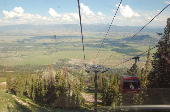
And I ended my day by scaring the bejeebies out of myself. There was this gondola, you see. It was free in the evenings. I thought it would be like the gondola at Crystal Mountain here in Washington state, which is a pleasant little ride. This was not a pleasant little ride. It turned out to be about three times as long and three times as steep, and by the time I got to the top, I was a gibbering idiot (I don’t do manmade heights, at least not ones like these). If you want to see what the view from the top looks like, click here. I left my camera in the car.
I almost couldn’t make myself ride it back down again, but a group with a baby(!) got in the gondola with me, and that happy little baby was a great distraction. Thank goodness. I’m not sure I’d have made it down sane without him!
Across the wide open spaces to some rather strange places
Southern Idaho, as I’ve said before, is a desert except where it’s irrigated. I was traveling across the path taken by the Yellowstone hotspot in ancient times — if you look at a satellite view of the region, you’ll see this sort of U-shaped giant-sized ditch in the land where, over the last few million years, the hotspot made its way from northeastern Nevada/southeastern Oregon, across Idaho, and up to northwestern Wyoming, erupting periodically along the way. What it left behind was a vast trough full of volcanic rocks of various kinds.
Which isn’t necessarily a bad thing. With enough weathering and the addition of some water, it can be transformed into hellaciously fertile farmland. Think about where all those famous Idaho potatoes come from. Although Washington actually grows more potatoes than Idaho does these days — but they do it on the same types of volcanic soil. Different eruptions, though.
Anyway. I headed southeast on I-84 to the Utah state line. Once upon a time, I drove this stretch of highway in January, moving from Eugene, Oregon, to Fort Collins, Colorado, and the landscape didn’t actually look all that different from today except for the skim of dusty white snow swirling across the highway back then. This is true high desert — don’t let the signs for Salt Lake City fool you.
I left the highway at the exit labeled #26 after crossing the state line, where the sign said, rather ominously, “NO SERVICES.” But that’s where the directions for the Golden Spike National Historic Site said I was to get off, and it’s not the most isolated place on the planet I’ve ever been (see Stanley, Idaho, night before last, which doesn’t take that pride of place, either). The other sign at that exit said, rather mysteriously, “ATK.” I had no idea what ATK was, but maybe I’d get to find out.
After coming over a rise and crossing abruptly from desert to irritated farmland, then going around a few miles worth of bends in the road, I found out what ATK is. Apparently it’s where they build rockets for NASA and missiles for the Defense Department. And they’re proud of it, because out in front of this big cluster of 1960s-era-looking buildings out in the middle of absolutely nowhere was something I’ll call a sculpture garden for lack of a better term.
ATK — a real surprise out in the Utah desert.
Bemused, I parked the car and took a gander. Each one was mounted on a big metal pole, and each had its own label telling what it was.
A Minuteman missile in ATK’s ‘sculpture garden.’A space shuttle booster rocket.
After goggling for a bit in the windy heat (it was well into the 90s that day), I got back in the car, fired up the AC again, and headed for a much older form of transportation.
Golden Spike National Historic Site, like Pompey’s Pillar (a Lewis and Clark site I visited a couple of years ago) has always sort of been on my nonexistent bucket list. It’s where the Union Pacific and the Central Pacific met in 1869, to form the first transcontinental railroad in the U.S. The event was celebrated by a bunch of dignitaries coming to this place out in the middle of the Utah desert just north of the Great Salt Lake (you can see the salt flats from a viewpoint at the site) to hammer a golden spike into the last railroad tie and ceremonially join the two railroads together.
Looking out towards the Bonneville Salt Flats and the Great Salt Lake from a viewpoint at the Golden Spike National Historic Site.
It’s an interesting place historically, and it’s also cool because the NPS keeps two replica steam locomotives on site, and runs one or the other of them daily at 1 pm for a short distance.
Steam locomotive at Golden Spike National Historic Site.The engineer’s cubby in the steam locomotive.Part of the authentic reproduction paint job. This is a portrait of Johnny Appleseed.
I ate a picnic lunch while waiting, after having been told by the ranger that I couldn’t bring my food indoors into the AC because they had a small mouse problem (I’m pretty sure it was the mice that were small, not the problem).
Then I got to see cutting edge transportation from the 19th century, smokestack, whistle (loud!) and all. Which was pretty damned cool (unlike the weather).
The locomotive in action.
After the demonstration, I headed east again on a backroad that thought it was a roller coaster, back down, down, down to cross I-84 again and on to the city of Logan, Utah. I hadn’t checked email in a while, and I needed groceries and gas. What ended up happening is that I got really lost trying to find the library (for email — my netbook no longer being wifi capable), but I finally made it out of town after a stop at a ranger station to make sure I was on the right road (there wasn’t a sign to be seen), where the ranger gave me a wonderful pamphlet about Logan Canyon, which was where I was headed.
And that’s how I ended up camping at Sunrise Campground in Utah, overlooking Bear Lake, up in the aspens where it was lovely and cool and the wildflowers were everywhere.
Oh, and I sold a copy of Repeating Historyto a couple I struck up a conversation with at the campground. Which is the first time that’s happened. I’m glad I took the print copies with me.
Woke up in an utterly peaceful place. Didn’t stay there long…
The Sawtooth Mountains early in the morning weren’t quite what they’d been the evening before, mostly because I was looking at them from the wrong direction. Still beautiful, however. I ate breakfast on the same porch I’d sat on the previous evening, then packed up and headed back south again.
Sawtooth Mountains near Stanley, Idaho.
Stanley, Idaho, is a few miles to the right of the tip of two highways forming a sharp V shape, and a large part of the righthand section, down which I aimed to drive today, is within the Sawtooth National Recreation Area, a place I suspect would have been a national park had the locals not been seriously agin’ the idea (after having watched what happened when David Rockefeller bought up most of Jackson Hole and given it to the feds for a national park).
As it is, a large chunk of the Sawtooth NRA is designated as wilderness, and the rest is much less regulated. And beautiful. The Sawtooths are amazing, just as jagged as their namesake and still partially snow-covered even in late June. My first stop was at Redfish Lake, the name (after the sockeye salmon which used to spawn here) of which I remembered from a trip my parents and I made here when I was somewhere between eight and ten.
Redfish Lake, Sawtooth National Recreation Area, Idaho.Sawtooth Mountains above Redfish Lake.Clear water at Redfish Lake. I love this texture.
When I last spoke with my mother, her primary memories of the place involved mosquitoes the size of small helicopters, but even though I spent some time walking along the lakeshore and out onto a pier, I didn’t run across a single one.
I did, however, see some lovely wildflowers.
They’re penstemons, and I can’t get any more specific than that, alas. They’re much more electric blue than in the photo.Some things are just too weird to believe without a photo — just north of Galena Summit.
After a couple of hours, I headed south, down the valley, where the mountains weren’t the only view, and up over Galena Summit.
The view from Galena Summit.
It was a terrific place to admire the view, and only a few miles down the road was a lodge where I ate a delicious lamb burger for lunch. After that, it was on down to Ketchum and Sun Valley, the world-famous ski area and home of the U.S.’s first chairlift, built back in the 1930s. Unfortunately, Sun Valley looks like someone took a chunk of Southern California and dropped it into Idaho. So about all I did was go find the Ernest Hemingway Memorial (not that I’m a huge Hemingway fan, but I was an English major), and got back out on the road.
The Ernest Hemingway Memorial, Sun Valley, Idaho.
I left the mountains behind not long after that, and had to make a decision, whether to go to Craters of the Moon National Monument, which I’ve visited twice before, or to head down into Utah to visit the Golden Spike National Historic Site, which I hadn’t. Golden Spike won out. But that was too far for one day, so once I reached I-84 again I started looking for a motel without much success. One of the few disadvantages of not deciding where you’re going until the last minute is that you can’t make reservations. Most of the time it’s worth it. But this time I was beginning to wonder what the heck I was going to do if I didn’t find something.
At last I saw a sign off the freeway in the town of Heyburn and went to check it out. It looked reasonable enough, and the price was right, but most of the rooms were full of road construction workers, and while that didn’t bother me, the manager went to great lengths to reassure me that he and his family lived on the premises, and that the construction workers were harmless. It was all rather amusing. And that was the end of the third day!
In which our traveler spent a morning with flowers and an afternoon wondering if she was ever going to get there.
It was already getting hot when I left Ontario, Oregon, and crossed into Idaho. Heat shimmering off the pavement and all that. But I stopped at the first rest area along the interstate, doubling as a welcome center, and stepped out to take a look at a nicely full Snake River, wending its way across southern Idaho on its way to meet up with the Columbia. It’s always good to see a river with plenty of water in this part of the country (east of the Cascades, west of the Rockies). The Snake was a lifeline for the pioneers on the Oregon Trail, too.
Snake River west of Boise, Idaho.
It was only an hour’s drive that morning to Boise, the state capital, a pleasant town along the Snake that has a great deal in common with many other western state capitols; while Boise is the largest city in Idaho, unlike Salem or Olympia or Helena or Carson City, it’s got that “we’re the seat of government because of some historical accident, not because this is where things happen” sort of vibe down pat.
The Idaho Botanical Garden is situated on the grounds of the old state penitentiary, of all things, and the ruins of the 19th century stone buildings look almost like some sort of antique backdrop to the acres of beautiful landscaping.
Rose garden at the Idaho Botanical Garden, with the old penitentiary as a backdrop.
The trouble with visiting places like this in other climates is that they grow things I would love to be able to grow but can’t. I realize I live in a very favored climate where many choice plants flourish with abandon, but it still makes me jealous that flax, for instance, its flowers looking like bits of the sky fallen to earth, won’t make it through our rainy winters. Then again, I wouldn’t appreciate botanical gardens in other climates so much if it did.
Blue flax and pink Clarkia, named after you-know-who.
The highlight of the Idaho Botanical Garden was the Lewis and Clark Garden, featuring plants that L&C discovered while they were in Idaho, each labeled by name with where they were found. The garden path wandered back and forth up the hillside to a statue of Sacagawea and a view across Boise to the Snake River and beyond. Quite lovely.
Native rose along the path in the Lewis and Clark garden.Statue of Sacagawea at the top of the path in the Lewis and Clark garden.
I filled the gas tank for a second time in Boise, and ate lunch while trying to choose whether I wanted to drive 300 miles down to Great Basin National Park in Nevada or northeast up into the Idaho mountains. I decided on the latter. Great Basin NP will have to wait for another year.
The road up through the dusty desert foothills into the Sawtooth Mountains was steep and winding. And seemingly endless. At first I wondered if there were going to be mountains at all, as I passed by a dam that made me laugh:
*What* forests???
But as I went farther on pine trees started to appear and the hills were covered in mock orange (Idaho’s state flower) in full bloom.
Mock-orange was everywhere.
I stopped in Idaho City, one of Idaho’s earliest settlements and a gold mining town (of course), and visited the Boise Basin Museum which told all about its history, including a 10-minute film narrated by, of all people, Tennessee Ernie Ford, who spent some of his later years here.
Self-evident.
After that entertaining interlude, I kept going, thinking I’d spend the night in Stanley, one of the most remote towns in the Northwest but only about a hundred miles on. I must admit that was the case — that it’s one of the most remote towns, if you can call it a town with a population of 63. I drove and drove and drove that afternoon, up through a canyon and into the mountains. I was stopped at one point by a traffic accident involving a motorcycle that seemed to have been going around one of the many sharp curves too fast. The motorcycle was lying on its side, and its rider was on the ground with it as if he were still riding it. I was assured by one of the many people standing around that the ambulance was on its way. I suspect it took a while to get there, and I hope the rider wasn’t too badly off.
At last I reached Real Mountains ™, snowcapped and jagged and glorious. I also reached miles and miles of roadside covered in bundles of dead trees. I found out later that the cause was pine bark beetles.
But when I finally reached Stanley, in a lovely broad meadow surrounded by mountain peaks, I found a sweet little log cabin with my name on it, and sat out on its porch for the evening enjoying the peace and the beauty. It was so quiet there that I could hear a car coming for miles before it passed by. Perhaps half a dozen of them passed by that evening before the stars came out, it got chilly (I’d gained a few thousand feet in elevation from Boise), and I finally went inside.
Beautiful (and I do mean beautiful) downtown Stanley, Idaho.
Two weeks ago today I headed out for parts unknown. Well, at least some parts, and at least some of them were unknown to me. And I didn’t know I was going anywhere until four days before I left. Things happen that way sometimes, especially when my feet get itchy.
I have raced across Idaho on my way to Yellowstone a fair number of times in the last fifteen years, straight across the narrowest part just south of Canada on I-90, less than 80 miles between Washington state and Montana. So this time I decided to take the long way around, and explore Idaho, part of Wyoming, and even a little bit of Utah along the way.
But first I had to get across Washington. Normally that’s another I-90 buzz across to Spokane, a five hour drive to the Idaho state line, but I wanted to do things a little differently. This time I went south and east, skirting the eastern edge of Mt. Rainier National Park and heading over Chinook Pass on U.S. 410. The pass was clear and dry, but it’s obvious that it’s only been open a few weeks judging from the amount of snow still lying about on the mountainsides. I left that behind quickly, though, and, with one stop at a fruit stand for a bag full of Rainier (of course) cherries the size of small plums, I was through Yakima and on I-82 to I-84, across the Columbia River, and into Oregon.
Most of the interstate through eastern Washington is through the high desert where it isn’t being irritated, as my father used to say, by those huge sprinkler farms. But less than an hour after I crossed my first state line of the trip, I started climbing again, and when I reached a rest area in the pines at the summit, it was to find an exhibit about how this was the last pass the pioneers on the Oregon Trail had to surmount. It was about twenty degrees cooler than the 90s down in the valley and the view went on pretty much forever. I also saw my first wildflowers of the trip, gaillardia and cow parsnips.
Gaillardia at Emigrant Springs waysideBlue Mountains and Oregon high desert
My first planned stop of the trip was near the town of Baker City, Oregon, almost all the way to Idaho a couple of hours further on. A lady on my online quilting list had mentioned stopping at the Oregon Trail Interpretive Center, and, history buff that I am it sounded interesting.
The center is five miles off the interstate, back in the high desert of far northeastern Oregon, and way up on a hilltop overlooking the valley and the Blue Mountains and, not incidentally, the still-visible wagon tracks from the 1840s, which were quite amazing. The building itself looked new, and the exhibits, says the freelance curator, were top-notch.
Entrance to the Oregon Trail Interpretive Center, Baker City, Oregon.One of the exhibits at the Oregon Trail Interpretive Center.Panel pointing out landmarks, including the wagon tracks, second from left, at the Oregon Trail Interpretive Center.
I know my western history fairly well, but I still learned things I didn’t know about the Oregon Trail. And I ran across an old friend, so to speak, when I saw a panel on Ezra Meeker, whose mansion is in Puyallup, where I did my internship. Ezra came out to Washington on the Oregon Trail in 1851, and spearheaded the campaign to save and preserve the trail back in 1906-08 by retracing his steps along it all the way to the other Washington, where he met with President Theodore Roosevelt about it.
It was getting on in the afternoon by the time I pried myself away from the center, and I only drove one more hour, to Ontario, Oregon, on the Idaho border, crossing over into the Mountain Time Zone in the process.
And I suspect I'm not going to have the time to go back and get caught up on either DW or LJ. So if there's something that happened in the last ten days that you think I should know about, I would greatly appreciate a direct link [g].
I will be posting all about my latest road trip starting on Saturday ("two weeks ago today, I...").
Thanks to Marja McGraw at http://www.blog.marjamcgraw.com/ , I have been tagged once more for the Writing Process Blog Tour, so in case anyone missed it the first go round, here it is again!
If any of you follow more writers besides me, you’ve probably seen others doing the Writing Process Blog Tour, in which different writers discuss the stories they’re working on and how they do it. They tag the writer who tagged them, and find other writers to join in. What you get out of it? Finding new writers and spreading the word!
Here are my answers:
What Am I Working On? Right now, I’m working on what I hope will become the first book in another series, set in what will later become Mt. Rainier National Park. My hero is a young man from Savannah, Georgia, who is traveling west in the summer of 1885 in hopes of a cure for his consumption (tuberculosis, very common but as yet uncurable at that time, although not always fatal in the short term), but also to escape from his smothering family. And that’s about exactly how far I am with Stephen’s story right now, except that it does have a title: Zoetrope, which is also the name of a simple 19th century gizmo for creating the illusion of moving images, which may give you a slight idea as to where I intend to go with this one. Or not.
I’m also revising my “highway patrolman crashes his cruiser out in the wilds east of the Cascade Mountains and finds himself in the local equivalent of Brigadoon” story. Brigadoon if it wasn’t silly and full of music, that is. That one’s called Sojourn.
How Does My Work Differ From Others Of Its Genre? I’ve never actually run across other books in my particular sub-genre, which isn’t to say that they don’t exist. My books are fantasy, but they’re not quest fantasy or urban fantasy. Definitely not urban. Almost all of them are historical because they involve time travel and other fantastical hijinks, but they’re not in located in the usual settings for historical fantasy, even though there’s a lot of straight historical fiction, and other time travel novels for that matter, set in the Old West, but not any fantasy set in national parks that I’m aware of. Love stories are central to all of my books, but only one of them is a genre romance, and it’s contemporary. It’s also something of an aberration, because I have no other genre romances in the works. I have to admit this has made my Yellowstone trilogy-plus (the plus being the short story “Homesick“, which is available for free through my website) the marketing challenge from heck.
Why Do I Write What I Do? Because I have a penchant for looking at perfectly ordinary things and thinking, “what if?” Well, okay, Grand Geyser is not ordinary in any normal sense of the term, but I don’t know of anyone else who has watched the Grand erupt in all its glory and thought, “wouldn’t that make a terrific time travel device!” A lot of my writing (like much of my own sense of identity) is inspired by a sense of place, and from learning about a place’s history. The people generally just show up and tell me that I need to take their dictation about the bizarre adventures they’ve had, which isn’t to say that they’re not important. I read for character, pretty much full stop, so I write for it, too.
How Does Your Writing Process Work? Lois McMaster Bujold once talked about her writing process as “writing to the next event horizon.” That’s pretty much what I do, too (imitation being the sincerest form of flattery, especially when it works). I brainstorm the plot until I’ve gotten as far as I can get, then I sit down and write up to that point, then I brainstorm till I’ve hit the next event horizon, then I write to that point, and so on and so forth till I’ve reached The End.
I like to know the end point I’m aiming for early on, but that doesn’t always happen, and even when it does it often changes before I get there. The only time I actually knew the very last sentence in the book when I started was with True Gold, my Klondike Gold Rush novel and the second in my Time in Yellowstone series (yes, I managed to get Yellowstone into a Klondike Gold Rush novel – if you want to know how, read the book [g]). I won’t say what it was because it’s a spoiler, but I knew from the very beginning exactly who was going to say the last line, and what he was going to say. And he did!
Vee at Honeylemontea (I just love the name of her blog) has interviewed me about True Gold, my Klondike Gold Rush novel. She had some very interesting questions, and I think at least one of my answers was something she did not expect.
Well, actually, to the Lakewood Historical Society’s new exhibit, which I researched, designed, created, and installed (in my other life as a freelance museum curator), about Lakewood’s long and deep connection with the military, from Fort Steilacoom in the mid-1800s, through Camp, later Fort, Lewis and McChord Air Force base, and on to what is now called Joint Base Lewis-McChord. Anyway, here are some photos of the exhibit, which I finished installing today, and which opens on Saturday. Do forgive the photography. Using a flash in the museum is not a good idea, and I obviously need to buy a tripod.
The introductory panel, with two photos of the main gate at Fort Lewis, one not long after it was built during WWI, and the other as it is now.
The first exhibit case, including a Civil War era forage cap from Fort Steilacoom on the right, and a WWI era hat and bugle from Camp Lewis.
The panel about Fort Steilacoom and the early maneuvers in the Lakewood area.
A timeline panel, a few photo panels, and the panel about Camp Lewis.
Another timeline and more photos. The panel in the upper lefthand corner is a reproduction of WWII-era “smileage coupons” purchased by civilians, given to soldiers, who could redeem them for movie tickets, food, and other non-necessities.
The other exhibit case, full of commemorative regimental coins and a plaque with a replica Stryker vehicle from Lakewood’s community connector program. Oh, and three sets of dog tags. One from WWI, one from WWII, and one from Vietnam, all from local soldiers.
And more photo panels as well as the panel telling about JBLM and the community connector program, which connects local communities with specific military units as a mutual support program.
If you are in the vicinity (here is the link to the Lakewood Historical Society’s website) between noon and two o’clock on Saturday afternoon, May 3rd, for the grand opening, we’d love to see you there. And if you can’t make it then, the exhibit will be open to the public until next spring — the museum’s hours are noon to four, Wednesday through Saturday.
The blog description does say, “and the occasional cat.” So here are two occasional cats. The solid is Ivan, and the stripes (tabby) is Ted.
I have a number of photos of their predecessors snuggling together in that chair, but this is the first time I’ve been able to catch Teddy and Ivan together like that.
We had temperatures over 70dF over the weekend, so I went to my favorite walking trail yesterday, and this is what I saw:
Mt. Rainier from the ballfields at the beginning of the trail.
I think these are some sort of feral crabapple.
This is what they look like from a distance.
This is just a view down the trail.
Bloomed-out pussy willow blossoms.
This flower is called Siberian miner’s lettuce, poor thing.
Elderberry blossoms.
Salmonberry blossoms.
More trail through the Douglas firs.
Wild currant blossoms.
Western bleeding heart blossoms.
That’s a fair number of species in bloom for this early in the year.
And then I came home, where I couldn’t resist a photo of the phlox and aubrieta that ate New York. I brought both of these home in four-inch pots about nine years ago.
Lavender creeping phlox twining with purple aubrieta along my front walk.
See? More proof of spring (I always need as much proof of spring as I can get this time of year).
The Skagit Valley in northwestern Washington state grows more bulbs commercially than the Netherlands does, and the results in the spring are rather spectacular.
My friend Loralee and I made the tulip festival there our annual birthday jaunt yesterday, and I wanted to share some photos I took.
The first thing we actually saw wasn’t tulips. It was a huge flock of snow geese, out in an empty field chowing away:
Snow geese in the Skagit Valley.
Then, a couple of miles later, we found tulip fields:
Tulips, as far as the eye can see.
And more tulips.
And yet more tulips.
After a pleasant waterfront lunch of fish and chips in the rather touristy town of LaConner, we went to the display gardens at Roozengaarde, which I think is the biggest bulb grower in the valley. At any rate, they’ve got some seriously spectacular display gardens:
So much color!
My eyes just soaked the color in.
They even had a maze made of flowers.
It was a beautiful day, and there were lots of us there enjoying it. I’m glad we went on a weekday, though, because I suspect the weekends are pretty much a zoo.
But, oh, it was pretty, and my eyes are happy, and it’s officially spring.


