From the mess my condo has become, so I took a walk.
This is what happens when you have the warmest April on record. Some flowers get blasted, and some bloom way too early.
With bonus birds.
This is Thimbleberry in blossom. The flowers are about an inch across.Wild roses blooming already. This is why I love my new camera. Taken with zoom of a blossom a good eight feet away.Lush, greenery along the path.Cranesbill, aka hardy geranium.This is why Indian plum is called Indian plum. Do note, however, that each fruit is only about a quarter of an inch long.The last of the Siberian miners’ lettuce.Wild peas. Over a month early (they don’t normally start blooming till late June).Small, loud bird (I don’t know what he is, but I suspect a sparrow). The woods are *full* of chirping this time of year.This is a rob-bob-bobbin, as my father used to call them, otherwise known as an American robin. He was one of two robins having a knock-down drag-out fight. Or sex. I wasn’t quite sure which.This is what happens when those pink salmonberry blossoms fall off.And a mama mallard. Papa was just out of the shot behind the bushes, as were the babies.
And that was what I did while taking a break and a walk at the same time this evening.
I have just returned from my annual trip to Tyler, Texas, to visit my almost 92-year-old mother, and, this time, to make a short (three-day) jaunt with my sister, who lives down there, too. We planned this several months ago, before all of the problems with my condo made me decide to sell it and take another Long Trip, and the plane tickets were already bought, so I didn’t try to cancel it.
Mt. Rainier from the plane on the way down to Texas.
Anyway, Mother is getting more and more fragile. I won’t get into her health issues here except to say how grateful I am that she’s still alive for me to go visit. I stayed with my sister Ann, and that’s only one reason I’m grateful she’s down there nearby for Mother.
Anyway, I’d been wanting to go to Austin and San Antonio and the Hill Country for a long time, and since this time I had to rent a car, anyway, I decided to go, and to invite Ann to go along with me. After a couple of days visiting with my mother, we headed south to San Antonio.
One of the nice things about Tyler is that to go any direction but due east or west, you pretty much have to get off the Interstate. The drive to San Antonio, aside from missing one turn, not realizing we had until we’d gone too far to turn back, and having to reroute ourselves, was fun. Wide open spaces, small towns, and wildflowers scattered all over the roadsides.
We arrived in San Antonio in the late afternoon, and found a hotel within walking distance of the River Walk and the Alamo, and went to eat supper along the River Walk. The River Walk reminded us both a bit of certain parts of Disneyland, but it was still fun (and about 10 degrees cooler than up on the street), and we ate fancy pizza right next to the water.
The next morning, it was raining just a bit. We strolled over to the Alamo under Ann’s umbrellas (she had two).
The Alamo.A close-up of where a cannon ball hit the Alamo during the famous battle.A view of the front of the Alamo from where we were waiting in line to get in. They don’t let you take photos inside.
I liked the Alamo. It was very interesting historically (they did a terrific job with the museum exhibit part of the thing), and the gardens were lovely. The rain was a minor nuisance, but not a big deal. Yes, the Alamo is basically a shrine to Texas, but I knew that going in, and, well, I eat history up with a spoon, so I had no problem with it.
A blooming cactus in the gardens beside the Alamo.
On our way back to the hotel to pack up and check out, we saw a whole bunch of carriages decorated as if for a wedding. Turns out we’d arrived the night before San Antonio’s annual Fiesta began. According to one of the carriage drivers, Fiesta attracts more people every year than New Orleans’ Mardi Gras, and was started when a bunch of ladies got drunk and flung flowers at each other 🙂
In the afternoon, we drove up to the Hill Country, which is sort of legendary for its spring wildflowers. It did not disappoint. After lunch in Fredericksburg, we took some back roads out through the rolling countryside (calling it hilly would have been stretching things, IMHO), and saw whole fields of flowers. Bluebonnets, of course, but also winecups and evening primroses and all sorts of things. Just gorgeous.
Bluebonnets!These are called winecups.I had to look this one up in my brand-new Texas Wildflower field guide. It’s called Prairie Pleatleaf, and it’s a member of the iris family.
We wound up spending the night in the town of San Marcos, just south of Austin, and came in for a rude surprise when we turned on the Weather Channel. A huge storm was headed our way. You might have seen the recent news reports about flooding in Texas? Well, we weren’t in Houston, where it got really bad, but the rest of it? We were right where it was about to hit.
So we decided to cut our trip short by one day and go back to Tyler the next morning.
People think it rains a lot here in western Washington, and we do get a fair amount. But it’s a soft rain. Texas rain is like driving through a bleeding waterfall. I’m not overly fond of thunder and lightning, either. At least we didn’t have any tornado warnings. But we made it back, and my only disappointment was that I didn’t get to go to the Ladybird Johnson Wildflower Center in Austin. Maybe next time, if there is a next time.
Once back in Tyler, the weather cleared up (bad weather seems to go around Tyler a lot of the time, which is really weird), and until I left several days later (having planned the trip with the jaunt in the middle so Mother could rest up while we were gone), I not only spent as much time as I could with my mother, but I got to stroll around a nature trail just down the street from my sister’s house, where there were also lots of wildflowers.
Faulkner Park, near my sister’s home in Tyler. So many different kinds of trees, and so many different leaf shapes and sizes.Red clover. I’ve never seen clover blossoms that big and that color anywhere else.Honeysuckle.Evening primrose (although this species actually keeps its blossoms open all day). Did I mention that I adore my new camera???
The last day before I left, Mother and I drove out to a place called Love’s Lookout, about fifteen miles south of Tyler, where there’s a nice little bench with a beautiful view, and we sat and talked for a while. It’s kind of our place, and I’m glad she was still able to go out there with me.
An autumn view from Love’s Lookout, taken in 2006. I didn’t take my camera with me this time, so you’ll have to imagine how lush and green the countryside was the other day.
And that was my visit to Tyler this year. Every year now I wonder if this will be my last visit with my mother. I hope not.
Waughop Lake is part of Fort Steilacoom Park in Lakewood, Washington. It used to be a farm for the mental hospital across the road, where the patients doing farm work was considered therapy back in the old days. Nowadays it’s a city park, with soccer fields and a bark park (as my sister calls off-leash areas) and trails. And an old cemetery managed by a wonderful group called Grave Concerns.
Waughop Lake is not a Native American name, even though it sounds like it ought to be, at least to me. It’s named after a former superintendent of the mental hospital.
Anyway, it was a lovely spring day, and my new camera lets me take much better photos than my old one. So here’s some of what I saw.
A view across Waughop Lake from the miniature boat launching area (they have races there in the summertime).Ducks. Mallards, although the angle of the sun makes it harder to see their coloration.Canada geese are ubiquitous around here.You may remember a recent photo I posted of some Glory of the Snow in my garden. These (and lots more) were growing in the grass near the lake. Back in the day, the wife of one of the former superintendents landscaped the area around the lake. It’s mostly gone back wild, but some of the non-natives still grow and thrive there.I’m not positive what this is. I’ve heard them called coots. They’re all over the place around water in this part of the world. Salt and fresh. ETA: According to my birder friend Katrina, this is an American Coot.Forsythia, a non-native, but gloriously sunshine yellow.I’m not sure what kind of bird this is, but there’s no way I’d ever have been able to take a photo like this with my old camera. ETA: Same source, Downy Woodpecker.Plum blossom. Everybody and his cousin has a pink or a white ornamental plum in his or her yard here.Not sure what this little guy is, either. The only reason I noticed him was because the closer I got to him the louder his chirps got. ETA: And this little dude is a Song Sparrow.The pussy willows are just about done already. But they’re so pretty.A view back towards where I took the first photo, from the opposite side of the lake.
I love my new camera. And the fact that we’re edging towards spring. This glory of the snow blossom is in my front flower bed, and I took the photo from a distance of about three inches, which is about two feet closer than I could have taken it with my old camera.
The maple key to the right of the flower is about two inches long.
It is the first of February, and astronomical spring is six weeks away. However, it is starting to look like spring at my house, and here’s the proof.
First, indoors, on my kitchen windowsill. My local grocery store sells pots of sprouting forced bulbs this time of year, and they’re so inexpensive I can’t resist. I’ll find a corner of ground to tuck them into once it warms up a bit.
Miniature daffodils, already a bit past their prime but still pretty.Reticulata iris.
And outside. Please forgive the weeds. I still haven’t cleaned up the garden yet. Soon.
The primroses I fell flat on my front porch buying last week. They’re a bit bedraggled because of all the rain we’ve been having, but they’re awfully cheerful next to my front door.Species crocus struggling up through last year’s dead stalks by my front door.Hellebores blooming by my back door. There’s also a hardy cyclamen in the lower righthand corner.
Oh, and something unrelated to plants, but definitely related to the weather: yet another needlework experiment. Someone posted on Facebook back in early January how they were going to make an afghan by crocheting one row every day. The color would be determined by the day’s high temperature. So I thought I would do it, too. Anyway, here’s the yarn:
Purple (below 45dF/7dC), blue (46-55dF/7-13dC), green (56-65dF/13-18dC), yellow (66-75dF-18-24dC), orange (76-85dF/24-29dC), and red (above 85dF/29dC). The green is much brighter than it shows in the photo, the purple isn’t quite that light, and the red is more cherry than the tomato it looks like.
And here’s the afghan at the end of the first month:
The first of January’s at the bottom. At the rate things are going, it’s going to be about 12 feet long by the end of December. Oh, well…
It won’t be officially astronomical autumn until the 22nd, or unofficially autumn until after Labor Day weekend, but still. It’s been feeling like autumn all week, cool and showery (and we had a very autumn-like windstorm on Saturday).
You can also tell because the hardy cyclamen are blooming beside my front door (please excuse the weeds).
Hardy cyclamen. I don’t remember if it’s hederifolium or neopolitanum or coum, sorry!
So today when I went for my walk along the Nathan Chapman trail, I decided to take my camera and see what I could see.
Here’s a shot of the beginning of the trail.
The northern end of the Nathan Chapman trail in South Hill, WA.
Here’s some blackberry foliage already beginning to turn color.
Blackberry foliage.
I don’t know what kind of berries these are. Currants, perhaps? The foliage does not say pyracantha or serviceberry to me.
Unidentified (so far) red berries. ETA: according to the Hardy Plant email list, they’re feral (and rather invasive, alas) white hawthorne (the white refers to the flowers, which indeed did come in big lovely white clusters last spring).
The photo below is part of the result of our very hot, dry summer this year. Things are starting to green back up now that we’ve had some rain, but some things won’t be back till next year now.
What the end of a hot, dry summer looks like.
The vine maple will be flame-colored in a few weeks, but for now it’s still green.
Vine maple leaves.
There are even a few flowers left.
Wild pea flowers.Wild asters.But the goldenrod has already gone to seed.
I found some blackberries, too, but the only ones that hadn’t been picked and eaten were up high enough to be at an awkward angle for photographing, so I’m not going to inflict my blurry efforts on you.
No Mountain today, either. Mt. Rainier is visible from where I took the picture below when the sky is clear. It should be out when my friend L and I go to Sunrise on Saturday!
The last of the Rocky Mountains, along the Trans-Canada Highway.
Two weeks ago, June 21 and 22, 2015.
So, yesterday was the Fourth, which means I didn’t spend a whole lot of time on the computer. Plus my monitor died Friday night. Fortunately, Best Buy was open on the holiday.
The penultimate day of my trip was the summer solstice. I also crossed back into the Pacific Time Zone, so it was quite a long day. I woke up at the crack of dawn again, into a gray-gloomy rainy day (which sounds so lovely right now — the temperature outside right now is over 90F, and has been for the last five days).
I’d had a reservation at a hostel in Kelowna, 215 miles down the road from Golden, but I’d decided to cancel it the previous night, because, well, now that I was on my way home, I wanted to see how far I could get. I always get sort of antsy the last day or two on the road on a trip like this — ready to get home.
I headed west again on the Trans-Canada Highway, through two more smaller national parks, Glacier National Park (yes, Canada has a national park called Glacier, too), and Mt. Revelstoke National Park, but there really wasn’t much reason to stop. The section through Glacier, over Rogers Pass, was the last section of the Trans-Canada Highway to be completed, in 1962. That road is younger than I am! There’s a historical site at what I’d call a rest area here in the States at the top of the pass, and I stopped to take a few pictures.
Approaching Rogers Pass, in Glacier National Park.Trans-Canada Highway monument, Rogers Pass.Looking east from the Rogers Pass Monument.
From there on it was down, down, down. I stopped in the town of Revelstoke, at a combo Tim Hortons and gas station, for liquid refreshment for both me and Kestrel, then turned south off of the Trans-Canada at the small town of Sicamous, onto Highway 97, which stays the same number in both Canada and the U.S.
Chicory flowers, near Sicamous, BC.
I drove past a pretty lake, and saw some blue wildflowers that had to be inspected and photographed, then south to the big city of Kelowna, where I arrived just in time for lunch (and was really glad I’d cancelled my hostel reservation). By that point, I’d left the lush forests of the western side of the Rockies behind, not to mention the rain and the cool temperatures. It was almost 30C, according to a bank thermometer in Kelowna, which translates to the lower 80sF, and not a cloud in the sky. It only got hotter the further I went, too.
The map had been somewhat misleading. I’d assumed that the double line that was Hwy. 97 through Kelowna meant that I’d be on a freeway, but no, just a four-lane boulevard with stoplights every hundred yards or so. It took me a while to fight my way through the traffic and reach the bridge across long, narrow Lake Okanagan. Then, after I was out of town, it turned into a freeway. Oh, well.
A glimpse of Lake Okanagan, south of Kelowna, BC.
Lake Okanagan is lovely, and the road clings to the cliff as it threads its way down past vineyards and through small towns and the good-sized city of Penticton. After Penticton, orchards were the order of the day, and I could have stopped and bought cherries any number of times. Alas, I was down to my last couple of Canadian dollars and didn’t want to get more at this stage, plus, I wasn’t sure if U.S. customs would let me through with them. So I didn’t.
Lake Osoyoos, BC.
I reached the U.S. customs station, just north of the little town of Oroville, Washington, along the shores of Lake Osoyoos (oh-SOY-oos — I asked the customs agent), about the middle of the afternoon. A very nice Hispanic lady checked my passport, asked me to take my sunglasses off for a moment so she could get a better look at my face, and to pop my trunk. If I’d known she was going to want to look in there, I’d have put all my dirty clothes back in my suitcase, but the only comment she made was how she, too, liked the brand of chips I had in my food bag. Oh, well, worse things have happened.
And then I was back in the land of miles and Fahrenheit (a rather high degree of Fahrenheit at that, almost 90 degrees, alas). I drove past Tonasket, which was the knot of the lasso of this trip, on to Omak, another hour or so, and got there around four. Found the motel I stayed at on my research jaunts for Sojourn, and crashed and burned. I’d been on the road since about 6 am Pacific time, and I slept like I was really working at it.
And the next day I got up and drove the five hours home, over familiar roads, down 97 past Wenatchee to Blewett Pass, to I-90 and home. I think I made three stops, one for gas and real MickeyD’s iced tea in Brewster, one just north of Wenatchee for cherries, and one just before I got back on I-90 to gather one last picnic from my cooler and food bag for lunch that I ate as I drove over Snoqualmie Pass. I got home about 2 in the afternoon. The condo hadn’t burned down and the cats were fine (although extremely eager to go outside, and beyond annoyed with me).
And that was my trip to the Canadian Rockies. Decidedly one of the best trips I’ve made in recent memory.
I don’t know the name of that hanging glacier (if it has one), but I thought it was cool. I have literally dozens of photos of mountains like this. Just amazing.
Thirteen days ago, June 18, 2015.
Off to Jasper! By way of the Icefields Parkway, which I’d been thinking of as the big highlight of the trip, and it did not fail me.
First, though, I want to mention a restaurant called Wild Bill’s (Peyto, not Hickok — a local fellow from the early days) in Banff townsite, where I ate the night before. Highly recommended, in an old-fashioned western sort of way. I had three sliders, one each of three different kinds, and a really good salad, and was treated to some boot-stomping music along the way.
Anyway, I was up and out early, checked out of the hostel, and walked to a local McDonalds — in a national park! — for a large hot tea (not even Mickey D’s does a proper unsweet iced tea up here <sigh>) before heading out of town, into enough on and off rain to clean my windshield.
And into a serious surfeit of stupendous mountains. The clouds came and went with the rain, but it was clear enough a good chunk of the time, and the cloud deck high enough when it wasn’t, that I had a good view most of the way. I did run into a bit of road construction just north of Lake Louise, but it wasn’t bad. And, after all, they have the same problem with road construction up there that they do in Yellowstone. A very short season for doing it, that coincides exactly with tourist season. Not much to be done about that.
Who cares about a little road construction when the view’s like this?
But the views were absolutely amazing. Mile after mile after mile of amazing. After a certain point I just sort of went on gorgeousness overload.
I *think* this is Crowfoot Glacier.And I think this is Bow Glacier. There was a lodge and a lake partially hidden in those trees.
So here are some highlights of a day that basically was all highlight:
I took a short but steep walk up to a viewpoint over Peyto Lake (named after the same guy as the restaurant — and pronounced PEE-to, not PAY-to), which was a beautiful strip of aquamarine dropped down in the evergreens. Lots of wildflowers, too.
Peyto Lake from the viewpoint.Arctic willow blossoms on the Peyto Lake trail.Wild yellow columbines at a picnic area along the parkway.
I stopped at another viewpoint just south of Bow Pass (over 2000m/6000 feet) to look back towards the Bow River Valley.
South from Bow Pass.
And I hiked about half a mile straight uphill to the foot of the Athabaska Glacier (which feeds off the Columbia Icefield, the largest icefield in the Rocky Mountains). It provided a graphic example of why living on a moraine as I do results in a garden full of rocks.
The trail up to Athabaska Glacier.Athabaska Glacier. A lady I spoke with there was disappointed that they don’t let people just walk up on the glacier anymore the way they did when she was a kid.
It was cold up there. I was so glad for my heavy jeans and my insulated jacket — and the hoodie with the hood up underneath, especially when it started raining on me again on the way back down to my car.
Then I drove down, down, down, into into Jasper National Park and a climate zone that felt much warmer than at Banff townsite even though it’s over a hundred miles farther north (since Jasper townsite’s altitude is 3484 feet, and Banff townsite’s is 4800 feet, it makes a certain amount of sense — 100+ miles distance is negligible in comparison). It was also sunnier, which was pleasant.
I stopped at Sunwapta Falls, where three rivers come together to form the Athabaska River, which flows into the Arctic Ocean, which just flabbergasted me at the time. I knew I was far north, but really? The falls are pretty spectacular, too.
Sunwapta Falls.
And on to Athabaska Falls. This time of year, with the snowmelt, I was seeing all the waterfalls on my trip at their best. And more wildflowers, too.
The upper part of Athabaska Falls.Another part of Athabaska Falls. It was impossible to take a photo of the whole falls at once.Mertensia at Athabaska Falls.
Somehow, after I left the parking area at Athabaska Falls, I wound up on a sort of back road (not really another Bow River Parkway, but more like a paved forest service road back home) which wound north and eventually dumped me on the Parkway just south of Jasper townsite.
And so I arrived in Jasper townsite, which really reminded me of Libby. The scenery was different, but the ambiance was very similar. Small and remote (the nearest big city is Edmonton, about 225 miles, compared to Banff’s proximity to Calgary, only 75 miles) and touristy, but in a much more understated way than Banff. Unfortunately, my supper there was the polar opposite of what I’d had in Banff the night before, but even that didn’t dampen my spirits.
The hostel was several miles outside of town, and they assigned me a bed tucked way back in a corner, which was fine by me.
It was an incredible day. I was exhausted, even after just about 120 miles, but wow, was it worth it. And in a couple of days, I was going to do it all over again, in the other direction. After I explored Jasper.
From Radium Hot Springs to Banff, aka, why is there a city in the middle of a national park?
Canadians have a much different idea as to what’s appropriate in a national park than we USAians do. I knew that, in theory, before I made this trip. But there’s something just really odd about having what I think of as a gateway community (and a bloody big one) inside the national park as opposed to just outside its border. Let alone what looks like their equivalent of an Interstate highway right through the park.
But I get ahead of myself. Twelve days ago today I drove back up into Kootenay National Park, and what should I see right after I emerged from the red rock canyon? A bear! My first one of the trip, but not my last. I don’t have a good picture of him, alas — I’d already passed him before I could get stopped, and there was another vehicle behind me in the pullout so I couldn’t back up, so the two photos of him I do have were taken through the back window of my car (no way was I getting out of my car to get a better look — I pride myself on not being a touron, as the Yellowstone folks sometimes refer to people who seem to be aiming to win the Darwin award).
A bear!
I drove on, chortling about seeing a bear, up the route I’d taken yesterday and beyond, past Marble Canyon and up to the Continental Divide, which is also the border between Kootenay and Banff National Parks. I’m afraid my photo of the sign proclaiming this got sun-glared, but here it is, anyway.
The Continental Divide and the boundary between both Kootenay and Banff National Parks and the provinces of British Columbia and Alberta.They mean that about the wild roses, too, especially in Jasper NP. Geographically, I visited Alberta about the way I visit Wyoming when I go to Yellowstone.
It’s not far from the Divide to the junction with the Trans-Canada Highway (the aformentioned Interstate-alike), a four-lane behemoth of a road that bisects Banff NP. Fortunately, there’s an alternative, the Bow Valley Parkway, which is a winding two-lane that runs from just north of Banff the town to Lake Louise. I joined it about halfway between, just below the imposing and appropriately-named Castle Mountain (although apparently after WWII, it was renamed Eisenhower Mountain, of all things — that didn’t last long).
Castle Mountain, at the junction with the Trans-Canada Highway, hence the light poles.
The Bow Valley Parkway is much more traditionally national parkish. Lots of pullouts with informative signs, trailheads, and so forth, and very peaceful, with one exception. I had thought to stop at Johnston Canyon, which was the second of those narrow, deep slot canyons, this one with a trail that goes along the bottom, but the parking area for the trailhead was so full that I couldn’t find a place to park. So I told myself I’d come back the next day, and kept going south to Banff the town.
Along the Bow River Parkway.One of the ubiquitous Columbian Ground Squirrels, which actually remind me more of prairie dogs than ground squirrels.
Banff the town is beautifully situated, surrounded by some really oddly-shaped mountains (I have to say that I’ve never really seen mountains shaped like the Canadian Rockies anywhere else), and where the Canadian national parks began with a hot spring (more on that tomorrow). It’s also incredibly busy and touristy, but I really didn’t mind. Especially since my hostel, right on the Bow River (pronounced like bow and arrow, not bow or curtsey), was within walking distance of practically everything. The hostel was in a huge old building that used to be a hospital, but it was clean and pleasant and if it felt a bit institutional, that was okay, too.
The bridge across the Bow River in the town of Banff.
After lunch in a restaurant (in a mall! in a national park!), I went exploring. Found the Bow River Falls, which were gorgeous.
Downstream from the Bow River Falls. This looks so much like Yosemite Valley to me.Bow River Falls.
Visited the Cascade Gardens behind the big stone Banff park admin building, which were another anomaly, albeit an enjoyable one, from my point of view.
A view from the Cascade Gardens.Lily of the valley blooming in Cascade Gardens. Everything was blooming about a month later than at home, and they were just putting out bedding plants for the summer.Cascade Gardens and the Banff admin building.
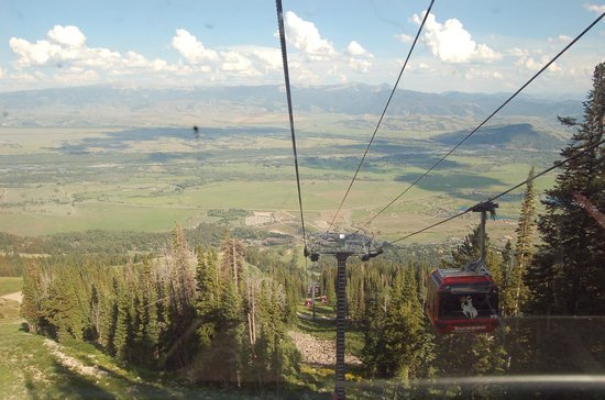
Wandered through the public rooms of the Banff Fairmont Chateau Hotel, which was much less iconic looking on the inside than it was on the outside, and drove up to the foot of the gondola, decided that it was not for me (I don’t do manmade heights, and this one made the one at the Tetons that scared me half to death last summer look like a quick lift to the top of the bunny slope), and ended up parked in the shade in their parking lot writing in my journal and enjoying the view.
The Banff Fairmont Chateau Hotel.A view from the patio of the Banff Fairmont Chateau Hotel.
I’d meant to visit at least two of the museums this afternoon, but it was Sunday and they were closed. So I put them on my agenda for tomorrow.
I like Banff the town. It’s just not my idea of what should belong in a national park, is all.
Wild rose at the logging historical exhibit west of Sherman Pass.
Twelve days ago, Friday, June 12, 2015
I think it was about three months ago when it was pointed out to me that I’m no farther from the Canadian Rockies than I am from
Yellowstone (about a hundred miles closer, in fact) and I thought, you know, I’ve been to Yellowstone how many times in the 22 years since I moved to western Washington — why have the only trips I’ve made to Canada in that time been a couple of weekends via ferry to Victoria?
So I renewed my passport and started making plans for the trip as soon as the exhibit was finished. That this happened to coincide with the dates the U.S. Open golf tournament was held less than
fifteen miles from my house was just a bonus (I am told the traffic that week was pretty overwhelming).
Anyway. As is normal on any first day of a vacation like this, I spent most of it on the road. Northeast on SR 18, where I began my day with a hawk stooping at prey right beside the road as I drove by, then east on I-90, of course, to the town of Cle Elum, just over Snoqualmie Pass, where I picked up a back road for a few miles to U.S. 97, which stretches north to the Canadian border, and,
incidentally, allowed me to bypass driving up I-5 through the entire
Puget Sound conurbation, plus avoid one of the busiest border crossings between here and Detroit.
I did not, however, go straight up U.S. 97 to the border. I turned east at the little town of Tonasket, in the heart of the Okanogan country, to explore the northeastern part of Washington before I headed on. I’d always been curious about this area, but it was just a bit farther than I’d want to go for an overnight.
I don’t know if anyone familiar with eastern Washington who’s reading this is as surprised as I was to discover how mountainous the northeast corner of the state actually is. I mean, south of here it’s pretty much flat and seriously monotonous all the way from
Ellensburg to Spokane. But SR 20 climbs quickly up from the
Okanogan River valley and enters national forest land. I passed through the “town” (if there were half a dozen buildings, I’d be shocked) of Wauconda, crossed a 4500 foot pass, dropped down to the San Poil River valley at the town of Republic (which could be the twin of Libby, Montana, where I lived briefly a long time ago), then climbed steeply to Sherman Pass, elevation 5500 feet.
The Sherman Pass viewpoint looks out over one of those curvature-of-the-earth views, over mountains that had obviously been burned in the not-too-distant past. An exhibit board said that the fire had taken place in 1988, the same year as the Yellowstone fires, and the landscape looked similar to the park.
View of burned mountains from the top of Sherman Pass.
East of Sherman Pass were a couple of historic landmarks. The first one was the site of a CCC camp in the 1930s, with some fun
sculpture:
Metal boot sculpture at the CCC historical marker.Metal sculpture of a CCC worker at the CCC historical marker.
The second one was apparently about logging, but with no sign, it was kind of hard to tell. On the other hand, this is where I saw the first of many, many wild roses in bloom on this trip (photo at top).
I crossed the Columbia River, actually Lake Roosevelt above the Grand Coulee Dam, at the town of Kettle Falls, the namesake of which is now buried under the reservoir.
The Columbia River, from a viewpoint just west of Kettle Falls.
But it had an interesting little historical museum where I took a break from the road.
The Kettle Falls Historical Society Museum.
And then I drove the last few miles to the county seat of Colville (pronounced CALL-ville, not COAL-ville), where I spent my first night on the road!
Otherwise known as, why spring is my favorite time of year, hands down.
First, my front flower bed.
Blue lithodora, pink/purple thyme, yellow sedum, cranesbill seedlings, iris foliage, a lavender creeping campanula, and the last creeping phlox blossoms.
This is at the very front end of my flower bed. I love the tapestry this has become.
The mama round-leaved cranesbill, and Tiny Rubies dianthus.
This is about halfway down the bed to my front door. The ferny foliage in the upper lefthand corner is threadleaf coreopsis, and the tall spiky plants in the upper center are lilies.
The only iris that bloomed this year, alas.
And, no, I don’t have his name. But isn’t he gorgeous?
This is the backyard.
Hosta and coral bells — if I ever knew the variety names, I don’t anymore.
Another cool combination.
Whoa, Nelly. Nelly Moser clematis climbing the fence and the vine maple.
This was a tiny seedling about six years ago. Those flowers are bigger than my hand.
The purple clematis (no variety name, alas).
This was the clematis I thought I’d dug up a couple of years ago. Apparently I missed some root fragments. I figure if it survived that, it deserves to stay.
Columbines are supposed to be blue. I also have a yellow and a white that aren’t in bloom yet.
I love columbines.
And that is May in my garden this year. Well, except for the bleeding heart that ate New York, but something fell on it and crunched part of it, so it’s not looking so great right now, alas. It is still blooming, however.
Each one of those wind turbines is taller than the Statue of Liberty.
Serendipity and itchy feet. Metaphorical itchy feet, I hasten to add. Anyway, it’s spring and I was feeling the need to hit the road,
preferably to a place I’d never been before. This isn’t easy when I can only be gone overnight, after almost twenty-two years in the same county.
But I’d never been to the Palouse before, somehow. Granted,
because it’s down in the far southeastern corner of Washington state (slopping over a bit into Idaho), the Palouse (which is either where the horse breed Appaloosa gets its name or vice versa) is about as far from home as I can get without leaving the state, but still, it’s only about 250 miles one way. Not that bad.
So I packed up for an overnight, loaded the cats’ food and water dishes, and headed out.
I left I-90 where it crosses the Columbia River at the little town of Vantage, and followed the river downstream to where if you look across it, you can see the Hanford Nuclear Reservation, which was part of the Manhattan Project during WWII, where they developed the bombs our government dropped on Japan, and which is now the Superfund site to end all Superfund sites (I can only wish it would be the end of Superfund sites). From the highway, of course, you can’t see anything but barren hills, but there is a sign that tells about it.
The Hanford Nuclear Reservation sign.
And so on eastward, past orchards and through the little town of Othello and the hamlet of Washtucna.
Apple orchard in bloom along the river south of Othello.
I turned south again at Washtucna through the terrain known as the channeled scablands, which resulted from huge lava flows which were then carved when great glacial Lake Missoula flooded most of eastern Washington, leaving behind a great black jagged landscape looking about as desolate as a place can get.
But it’s a beautiful desolate, and one of the most beautiful places in it is Palouse Falls, which is also Washington state’s official state
waterfall.
190-foot Palouse Falls, Washington’s state waterfall.Looking downstream from Palouse Falls at the channeled scablands.Marmot near Palouse Falls.I thought this was camas, but it turns out to be brodiaea.
But no, I wasn’t in the Palouse yet. After I hiked around the falls a bit, and photographed a few wildflowers and a critter or two, I
headed on east and north, and the land changed abruptly from sharp and jagged and rocky to smooth and covered with a
patchwork of kelly green new sprouting wheat and fallow tan.
The undulating landscape of the Palouse.
The Palouse proper looks like the landscape version of a Renoir nude. Not a sharp edge in sight. The soil here, wind-blown loess up to a thousand feet deep in places, flows almost like water. The roads curve and wrap themselves around and through the undulating ups and downs topped with ranks of wind turbines. Farmhouses
surrounded with windbreak trees nestle in the hollows. The sky is unutterably wide, especially to someone who’s used to spending most of her time surrounded by huge evergreens and snowcapped mountains.
It’s actually quite glorious.
The biggest town in the Palouse is the college town of Pullman.
Everything there is Washington State University Cougar red and
silver. People kept telling me I needed to go to a place called
Ferdinand’s to get ice cream, but I couldn’t find it. I did, however, find a place to spend the night, the better to get ready for more
exploration the next day.
If you enjoy my travel blog posts, you might enjoy my travel memoir, Cross-Country.
One, the light is changing with the angle of the sun. Even when it’s warm and sunny, it looks different. And the nights cool off considerably more. We’re down to thirteen hours of daylight (from sixteen on the summer solstice), and losing several minutes a day.
The other is a bit more cheerful.
Cyclamen neapolitanum
This little clump of hardy cyclamen thrives in the dry shade by my front door, puts out pretty leaves every winter, dies back in the summer, then, once I’ve forgotten about it, does this every September.
Which makes sense. Last Sunday, I decided to go out to the Nisqually National Wildlife Refuge — the main link doesn’t seem to be working for some reason, but this one should — which occupies most of the estuary of the Nisqually River (the one I showed you the glacial headwaters of last week ). It’s the largest remaining undeveloped estuary on Puget Sound, and the site of a heated battle between developers and preservationists back in the 1970s, which resulted in the creation of the refuge.
The refuge used to be mostly diked farmland, and a few years ago, the management decided it would be better for the critters if the dikes were removed, so they were, and a beautiful two-plus mile boardwalk replaced the dike trails. The boardwalk leads to a gazebo at the very edge of the estuary, where you can see open water and most of the southern end of the sound.
For some reason, on this trip I didn’t see any critters on the way out to the gazebo except for gulls, but I saw lots on the way back. I’m not sure why that was.
The trail to the head of the boardwalk is mostly a boardwalk, too, and traverses forest of bigleaf maple and black alder. In spite of the trees, it’s mostly wetland, and this time of year the water is covered with bright green algae. Jewelweed blooms this time of year, too.
The boardwalk leading to the estuary boardwalk.Bright green algae covering the wetland.Jewelweed blossoms.
Then the forest stops and the estuary starts, and the sky opens up.
Out of the forest and onto the tideflats.You can see the gazebo at the end of the boardwalk, just to the left of the end of the bluff (not the dock and building, to the left of that). The white spots are gulls.Looking back towards the twin barns (there really are two, although you can only see one of them in this photo) at the beginning of the estuary boardwalk. The parking lot’s about half a mile past that.
I walked all the way out to the gazebo, which, like I said, is over two miles one way. The clouds kept coming and going. I kept wishing they’d stay, because it was warm, and out on the tideflats like that it was humid. Under the clouds it was fine. Under the sun, it was sweaty.
On a clear day, you can see all the way up to the Tacoma Narrows Bridge from the gazebo, a distance of somewhere between 15-18 miles as the gull flies.
If you look very closely, you can see one of the uprights on the Tacoma Narrows Bridge, dead center.
And then, on the way back, I saw Critters. With a capital Cr.
An egret. Isn’t he gorgeous? What I really want to know is how he stays so white out there in the mud.A great blue heron. I saw about half a dozen of these coming back, but this one was the closest.Another heron, who really isn’t headless (see his reflection?).My birder friend says this is a hawk, probably a red-tailed hawk just because they’re so common here.And, as the enthralled little girl I was watching this fellow with said, “a bunny!”
I also saw a lot of swallows out swooping around eating mosquitoes, but they were moving far too fast to photograph.
All in all, a wonderful day out at the Nisqually National Wildlife Refuge.
Yes, I woke up to more rain two weeks ago today. I drove back into the park, anyway, of course (it’s about thirty miles from West Yellowstone to Old Faithful), and parked Kestrel (my car) near the lodge. Still feeling optimistic about the weather at this point, I packed up my daypack with all the necessities for a day out in the geyser basin, including, but not limited to, my Kindle, my journal, and my cross-stitch (some geysers must be waited for, sometimes for up to three or four hours).
Fortunately, my daypack is waterproof and I have a good raincoat. My first stop was in the visitor center, to check the eruption predictions. Old Faithful itself goes off often enough that one can often catch it in passing while headed somewhere else, but Riverside only goes off every six hours or so, Castle every nine to eleven hours, and the Grand, that pinnacle of predictible geysers, erupts about every seven to eight hours, so if I wanted to see them, I needed to know when to go sit and wait for them.
Eruption predictions are never on the minute. Grand, for instance, has a three-hour window, which means that it’s most likely to go off up to an hour and a half on either side of the prediction time. Riverside and Castle were predicted to have morning eruptions, and the Grand wasn’t due to go off till late afternoon.
Anyway. About the time I left the visitor center, the sky opened up. Not quite raining in sheets, but in the five minutes it took me to walk from the visitor center to the Old Faithful Inn, I was fairly drenched where my raincoat didn’t cover me, and the visor of my hood was dripping.
Still, as I peered through the murk over towards Old Faithful, I did see Lion Geyser erupting in the distance. But I really didn’t want to get any wetter, so I used the zoom on my camera to get this shot.
The sign says Old Faithful. The actual geyser in the distance is Lion.
And instead of sitting out in the rain waiting for things to erupt, I went into the Inn and found myself a cozy spot and caught my journal up after several days of ignoring it. Not exactly what I’d had in mind, but there are much worse places to be stranded.
The 85-foot-tall, 500-ton (according to Wikipedia, at least), four-sided fireplace in the Old Faithful Inn, with its hand-forged clock.
An hour or so later the rain let up and I finally went out into the geyser basin. I walked out as far as Castle Geyser, which had apparently gone off during the rainstorm but was still bellowing (and I mean bellowing — the sound is pretty impressive) steam.
Castle Geyser, bellowing steam in the distance.
I turned right and headed across the bridge towards Sawmill, which was churning away as usual. I know the “real” geyser gazers don’t think much of Sawmill because it robs energy and water from other, rarer geysers like Tardy and Penta, but I like Sawmill, for its chugging sound (hence the name) and simply because it looks like it’s thoroughly enjoying itself.
Sawmill Geyser on the left, and what can only be Tardy Geyser on the right, unless I’m mistaken, which is altogether possible.
Most geysers do. I can’t help anthropomorphizing them that way. I just can’t. I’ve never met a more cheerful geologic phenomenon than a geyser, and that’s just the way it is.
A view of Geyser Hill from the old road.
I strolled around Geyser Hill, past Giantess (one of the biggest geysers in the world — and also one that I’ll probably never get to see because it erupts so seldom) and Beehive, which is not an officially-predicted geyser, but can be caught occasionally because it’s got what’s called an indicator, which is a small geyser off to its side that often starts erupting just before Beehive itself does. I’d missed it this morning, but here’s what it looks like from 2008, in much better weather, when I didn’t miss it.
Beehive Geyser, 2008, from the viewpoint across the river. Note the tiny people on the boardwalk next to it.
Then it started raining again, and it was past lunchtime, so I went to what’s affectionately known as the Lower Ham (Hamilton, although it’s no longer owned by the family) store, and ate lunch at the counter there. That lunch counter/soda fountain has been there a long time, by local standards. The store itself was first built in 1897, and Charley, who was still Chuck at that point, ate his last meal in 1959 there before he inadvertently time-traveled back to 1877 in Repeating History. It’s also where James first went looking for his son just after Chuck disappeared and met Jo in Finding Home. An important place, the Lower Ham store.
This isn’t my photo, but I wanted you to see what it looks like.
Then again, so is the whole Upper Geyser Basin, so far as I’m concerned. My short story “Homesick” takes place here, too, and one geyser in particular is very significant in both Repeating Historyand “Homesick.”
My only eruption of Old Faithful on this trip, taken from the shelter of the Lodge porch.A blue bird (not sure of exact species — ETA, my birder friend Katrina says it’s a mountain bluebird) which was hanging around Old Faithful just before the eruption. The rain started again a few minutes before the geyser went off.
It took the rain a while to let back up again, alas, although I did catch what turned out to be my only view of Old Faithful from where I’d walked back to the Lodge (as opposed to the Inn), and by the time it did, it was getting close to four in the afternoon, Grand’s predicted time. Of course, given the window, it could have already gone off, but I didn’t have anything to lose except the time and a little shoe leather, so I headed back out one more time. Except for the rain, this was a pretty normal geyser basin day for me. Out and back and out and back, watch this geyser and that, have a thoroughly good time.
Anyway, when I got back out to the Grand, there were still a fair number of people sitting and waiting. My spirits rose. And, lo and behold, less than ten minutes after I sat down, guess what happened?! Grand’s pool, which had already been overflowing, started generating little waves, Turban (a kinda sorta indicator) went off, and away Grand went! I think that’s the shortest amount of time I’ve ever waited for the Grand.
This is my alltime favorite photo of the Grand, taken in 1999 during the eruption that inspired Repeating History.
And it was. Grand, that is. Just one burst, but it was a good long one, and that was enough to make my day. Make my trip, actually.
Especially since I always think of the Grand as Charley’s geyser. It was a crucial half (the other half being an earthquake I’ll tell you about tomorrow) of the phenomenon that sent Chuck back in time to become Charley in Repeating History, and it also caused Charley’s son Will and — okay, this may get confusing — Will’s five-year-old grandson Chuck (yes, that Chuck) to witness something in “Homesick” that changed their lives forever.
The rain didn’t start back up yet again until I was back in my car and headed back to West Yellowstone an hour or so later, either, and that was a good thing, too.
Rain, rain, go away. There *are* mountains there, honest.
The temperature had dropped by about twenty degrees, which was lovely, but it was pouring rain, which was very much not.
I packed up from the very nice hostel at Teton Village and headed north, anyway. What else was I going to do? It did gradually clear up the farther north I went, and by the time I reached the part of the Tetons I’d been to before, the clouds were beginning to let those sharp, pointy mountains shred them a bit. (You do know what “tetons” means in French, right? — those fur trappers must have been out there a long time to make that particular association), and by the time I reached the southern entrance to Yellowstone, it had pretty much stopped raining, thankyouverymuch, although it was still nice and cool.
See, mountains! Shredding clouds, too.
I’d never approached Yellowstone from the south before. Because of where I live, I usually come at it through either the north or the west entrance. I missed out on entering via the northeast entrance two years ago because the Beartooth Highway (which tops out at almost 11,000 feet) was still blocked by snow in June. Anyway, it was an interesting change, and one that required me to show my parks pass three times today — once entering Grand Teton NP via the same goat trail I’d taken the day before, once re-entering GTNP via the Moran entrance (U.S. 89 is not officially part of the park, apparently), and once to get into Yellowstone itself. Weird.
It takes a while to get from the southern entrance to anything interesting except for Lewis Falls, which is pretty. I didn’t stop there this time, but here’s a picture from August, 2008, when the weather was much better.
Lewis Falls, in 2008.
My first real stop was at the West Thumb Geyser Basin. I’d never been there when the lake was so high before. Not only was Fishing Cone completely covered, but the water was actually lapping up underneath the shore boardwalk, and out the other side.
A submerged Fishing Cone. Don’t throw anything out there, please.See the water lapping up to the *left* of the boardwalk???
I love West Thumb. It’s as if TPTB said, where’s the prettiest place in the park to put some hot springs? And then put them there. There aren’t any regularly-erupting geysers at West Thumb, but it really is fetching.
West Thumb Geyser Basin and Lake Yellowstone.
In hindsight it wasn’t the best decision I’d made on this trip because of the weather (not today’s, but tomorrow’s), but I decided I would drive the Grand Loop today and do the geyser basin thing tomorrow and Saturday, so I headed north along the lakeshore. I stopped and ate lunch at the Lake Lodge cafeteria (which is absolutely identical to the one at Old Faithful, except for the view), then stopped again at the picnic area just north of LeHardy Rapids to look at the river.
Nez Perce Ford, where Charley almost drowned.
Historically, this is where the Nez Perce crossed the Yellowstone River on their flight to Canada, and so it’s where Charley and Eliza and Anna crossed the river in Repeating History, and Charley almost drowned. So it’s sorta special to me.
So’s the next place I stopped, the Mud Volcano. Sounds pretty exciting, doesn’t it? Well, it’s smelly, and it’s muddy, and it’s pretty violent. It’s also where James happened to be when he realized he was falling in love with Jo in spite of himself in Finding Home, so it’s another kinda special place for me.
Mud Volcano (aka one of the hundreds of photos I have of Authentic Yellowstone steam ), aka where James fell in love with Jo.
And so I kept going north. I drove through Hayden Valley and saw some red dogs (the local name for baby bison), which are adorable.
Red dogs! And their mamas.
I stopped at Canyon and admired the view from Artist’s Point.
The classic view of the Lower Falls of the Yellowstone, from Artist’s Point.
And I went up over Dunraven Pass, where I saw a flower new to me at the top of the pass (and, yes, the yellow ones are dandelions, just ignore them):
Purple (much more like red-violet than in the photo) phacelia — a new flower for me.
And around Tower Falls, and west across to Mammoth Hot Springs and drove the loop up and around. By then it was sunny and gorgeous. Go figure. There were no elk at Mammoth. There are always elk at Mammoth. I did not see a single elk on this trip. Go figure that, too.
Orange Mound Spring, aka orange Cthulu, at Mammoth Hot Springs, which used to be a lot more orange than he is now.
Then, because it was getting on in the afternoon, I headed south again, only to be brought to a dead stop because there were iris blooming in a small clear spot between the aspens just south of Mammoth. I’d never seen iris in Yellowstone before. My favorite flower in my favorite national park. It was just too cool to be true.
Iris! In Yellowstone! A bit overexposed, alas. They were darker blue than this.
It took me a bit to get going again after that. I stopped at Norris and walked around Porcelain Basin, where I saw a geyser I’d never seen before (it takes a fair amount for that to happen these days). It’s called Constant Geyser, but it does not live up to its name, so I was pretty lucky on that score.
Constant Geyser — at least I *think* I got the name right — first geyser I’ve ever seen erupt in Porcelain Basin, anyway.
I also got to listen to the tiny springs that sound just like butter sizzling in a frying pan, which amuse me vastly every time. They’re not very photogenic, but this is probably the best picture of one I’ve ever gotten in any number of tries over the years.
One of the larger “spitters” in Porcelain Basin.
After that, it was time and past time to go check in at the hostel in West Yellowstone, which, as it turns out, was sold to a new owner last spring. This was not an improvement, alas, but it was a place to put my head for two nights, and possibly for three if I didn’t mind paying for a single room instead of a bunk that third night. I signed up for all three nights, but, well… That’s a story for a couple of days from now.
I couldn’t wait to go back into the park tomorrow and wander around waiting for things to erupt.
Well, that was the only night I camped on this trip. For some reason I could not get comfortable in my sleeping bag, and I finally gave up about four in the morning. So I pulled out my Kindle and read till it got light at about 5:30, packed up, and headed out.
Not very far at first — the Sunrise campground sits at the very top of the long, steep drop to Bear Lake, and a very nice viewpoint/visitor center, which was unlocked even at that gawdawful hour of the day (much to my pleasure, as the campground only had pit toilets and no running water), is practically next door to it. So I got cleaned up and then sat and watched the sun rise over Bear Lake. It was fairly spectacular.
Sunrise at Bear Lake, Utah.
I decided I deserved breakfast out after that, and after descending 2000 feet (7900 to 5900) to Bear Lake and the small town of Garden City, I started looking for somewhere that might feed me one.
Nothing, and I mean nothing, was open in Garden City at six a.m., though, so I went on, heading north along the shore of Bear Lake. Eventually I crossed the state line back into Idaho, and found the small town of Montpelier, which was just waking up for the day. The lady at the gas station where I filled the tank for the fourth time on the trip told me the truck stop just north of town was about the only place to go to get breakfast (I did mention that Montpelier is a small town, right?). So I went to find the truck stop.
It turned out to be a nice place, as such things go, and the waitress very helpfully warned me that I only wanted one pancake, not a short stack. Wow, was she right. That pancake was about twelve inches around and at least half an inch thick. It was good, though, especially with Bear Lake raspberry syrup (the berries are a local specialty). I ate a bit more than half of it before I gave up.
I headed north and east on U.S. 89, the same highway that I took all the way to Yellowstone. Up and over a pass and into Wyoming, where I noticed that I was not as alert at the wheel as I could be, so I stopped in a forest service campground, let my seat back all the way, grabbed my pillow and afghan, and crashed for a couple of hours.
Much refreshed, I arrived in the town of Afton an hour or so later, where I got stuck in a bathroom line with a bunch of French-speaking bus tourists, and saw what is purportedly the world’s largest antler arch across the main drag in town. I did not get a photo of it, but if you click here you can get a look at it.
My goal for the day was the ski resort of Jackson Hole (no, not Jackson’s Whole — that would be the wrong Nexus, thank goodness), where I was going to spend tonight, and Grand Teton National Park, where I would spend the rest of the day.
I’d spent about half an hour on my cell phone last night in the campground — I don’t know why I’m still astonished that I can talk on the phone in places that remote, but I am — making sure I had a place to sleep tonight at the hostel in Teton Village (at the base of the ski resort) and for the next two nights (they didn’t have space after that — last minute trip planning can be a bear) at the hostel in West Yellowstone.
I hadn’t spent any time to speak of in the Tetons since I was a kid. In 1999 on my Long Trip (see my book Cross-Country: Adventures Alone Across America and Back) I’d spent an evening on a dinner cruise on Jackson Lake with some friends, and in 2008 my friend Mary and I passed through, stopping for a few photos, on our way from Yellowstone to Denver for WorldCon, but that was pretty much the extent of it. In all the rest of my jaunts to Yellowstone, I hadn’t bothered to come south even that far. So I wanted to spend a little time here, at least.
The Teton Mountains, Grand Teton (13,776 feet — almost as tall as Mt. Rainier) front and center.
The Tetons are spectacular, I’ll give them that, but they strike me as a bit — aloof. It’s hard to get out in them without doing a lot more hiking than I’m capable of. I stopped along the roadside to take pictures and to look at wildflowers (which were everywhere), and then at the visitor center at Moose, which was fun. Then I drove out to Jenny Lake and decided on a whim to take a boat ride across the lake to a trailhead that led to a waterfall.
The Moose at Moose — no real meece, alas, not on this trip.Scarlet gilia, which I’ve always thought of as a California wildflower before.Another view of the Tetons.
The boat ride was fun. It was also a great way to cool off from the 80+ degree temperatures. And the hike to the waterfall, albeit with a boatload of my new close friends, was good, too. So that was worth it.
Jenny Lake.From the boat on Jenny Lake.Hidden Falls, approximately 100 feet tall.Waiting for the boat to go back across Jenny Lake.
After the ride back, though, it was getting late, and I took what was supposed to be a short cut but turned out to be a goat trail back to Teton Village.
And I ended my day by scaring the bejeebies out of myself. There was this gondola, you see. It was free in the evenings. I thought it would be like the gondola at Crystal Mountain here in Washington state, which is a pleasant little ride. This was not a pleasant little ride. It turned out to be about three times as long and three times as steep, and by the time I got to the top, I was a gibbering idiot (I don’t do manmade heights, at least not ones like these). If you want to see what the view from the top looks like, click here. I left my camera in the car.
I almost couldn’t make myself ride it back down again, but a group with a baby(!) got in the gondola with me, and that happy little baby was a great distraction. Thank goodness. I’m not sure I’d have made it down sane without him!
In which our traveler spent a morning with flowers and an afternoon wondering if she was ever going to get there.
It was already getting hot when I left Ontario, Oregon, and crossed into Idaho. Heat shimmering off the pavement and all that. But I stopped at the first rest area along the interstate, doubling as a welcome center, and stepped out to take a look at a nicely full Snake River, wending its way across southern Idaho on its way to meet up with the Columbia. It’s always good to see a river with plenty of water in this part of the country (east of the Cascades, west of the Rockies). The Snake was a lifeline for the pioneers on the Oregon Trail, too.
Snake River west of Boise, Idaho.
It was only an hour’s drive that morning to Boise, the state capital, a pleasant town along the Snake that has a great deal in common with many other western state capitols; while Boise is the largest city in Idaho, unlike Salem or Olympia or Helena or Carson City, it’s got that “we’re the seat of government because of some historical accident, not because this is where things happen” sort of vibe down pat.
The Idaho Botanical Garden is situated on the grounds of the old state penitentiary, of all things, and the ruins of the 19th century stone buildings look almost like some sort of antique backdrop to the acres of beautiful landscaping.
Rose garden at the Idaho Botanical Garden, with the old penitentiary as a backdrop.
The trouble with visiting places like this in other climates is that they grow things I would love to be able to grow but can’t. I realize I live in a very favored climate where many choice plants flourish with abandon, but it still makes me jealous that flax, for instance, its flowers looking like bits of the sky fallen to earth, won’t make it through our rainy winters. Then again, I wouldn’t appreciate botanical gardens in other climates so much if it did.
Blue flax and pink Clarkia, named after you-know-who.
The highlight of the Idaho Botanical Garden was the Lewis and Clark Garden, featuring plants that L&C discovered while they were in Idaho, each labeled by name with where they were found. The garden path wandered back and forth up the hillside to a statue of Sacagawea and a view across Boise to the Snake River and beyond. Quite lovely.
Native rose along the path in the Lewis and Clark garden.Statue of Sacagawea at the top of the path in the Lewis and Clark garden.
I filled the gas tank for a second time in Boise, and ate lunch while trying to choose whether I wanted to drive 300 miles down to Great Basin National Park in Nevada or northeast up into the Idaho mountains. I decided on the latter. Great Basin NP will have to wait for another year.
The road up through the dusty desert foothills into the Sawtooth Mountains was steep and winding. And seemingly endless. At first I wondered if there were going to be mountains at all, as I passed by a dam that made me laugh:
*What* forests???
But as I went farther on pine trees started to appear and the hills were covered in mock orange (Idaho’s state flower) in full bloom.
Mock-orange was everywhere.
I stopped in Idaho City, one of Idaho’s earliest settlements and a gold mining town (of course), and visited the Boise Basin Museum which told all about its history, including a 10-minute film narrated by, of all people, Tennessee Ernie Ford, who spent some of his later years here.
Self-evident.
After that entertaining interlude, I kept going, thinking I’d spend the night in Stanley, one of the most remote towns in the Northwest but only about a hundred miles on. I must admit that was the case — that it’s one of the most remote towns, if you can call it a town with a population of 63. I drove and drove and drove that afternoon, up through a canyon and into the mountains. I was stopped at one point by a traffic accident involving a motorcycle that seemed to have been going around one of the many sharp curves too fast. The motorcycle was lying on its side, and its rider was on the ground with it as if he were still riding it. I was assured by one of the many people standing around that the ambulance was on its way. I suspect it took a while to get there, and I hope the rider wasn’t too badly off.
At last I reached Real Mountains ™, snowcapped and jagged and glorious. I also reached miles and miles of roadside covered in bundles of dead trees. I found out later that the cause was pine bark beetles.
But when I finally reached Stanley, in a lovely broad meadow surrounded by mountain peaks, I found a sweet little log cabin with my name on it, and sat out on its porch for the evening enjoying the peace and the beauty. It was so quiet there that I could hear a car coming for miles before it passed by. Perhaps half a dozen of them passed by that evening before the stars came out, it got chilly (I’d gained a few thousand feet in elevation from Boise), and I finally went inside.
Beautiful (and I do mean beautiful) downtown Stanley, Idaho.
Two weeks ago today I headed out for parts unknown. Well, at least some parts, and at least some of them were unknown to me. And I didn’t know I was going anywhere until four days before I left. Things happen that way sometimes, especially when my feet get itchy.
I have raced across Idaho on my way to Yellowstone a fair number of times in the last fifteen years, straight across the narrowest part just south of Canada on I-90, less than 80 miles between Washington state and Montana. So this time I decided to take the long way around, and explore Idaho, part of Wyoming, and even a little bit of Utah along the way.
But first I had to get across Washington. Normally that’s another I-90 buzz across to Spokane, a five hour drive to the Idaho state line, but I wanted to do things a little differently. This time I went south and east, skirting the eastern edge of Mt. Rainier National Park and heading over Chinook Pass on U.S. 410. The pass was clear and dry, but it’s obvious that it’s only been open a few weeks judging from the amount of snow still lying about on the mountainsides. I left that behind quickly, though, and, with one stop at a fruit stand for a bag full of Rainier (of course) cherries the size of small plums, I was through Yakima and on I-82 to I-84, across the Columbia River, and into Oregon.
Most of the interstate through eastern Washington is through the high desert where it isn’t being irritated, as my father used to say, by those huge sprinkler farms. But less than an hour after I crossed my first state line of the trip, I started climbing again, and when I reached a rest area in the pines at the summit, it was to find an exhibit about how this was the last pass the pioneers on the Oregon Trail had to surmount. It was about twenty degrees cooler than the 90s down in the valley and the view went on pretty much forever. I also saw my first wildflowers of the trip, gaillardia and cow parsnips.
Gaillardia at Emigrant Springs waysideBlue Mountains and Oregon high desert
My first planned stop of the trip was near the town of Baker City, Oregon, almost all the way to Idaho a couple of hours further on. A lady on my online quilting list had mentioned stopping at the Oregon Trail Interpretive Center, and, history buff that I am it sounded interesting.
The center is five miles off the interstate, back in the high desert of far northeastern Oregon, and way up on a hilltop overlooking the valley and the Blue Mountains and, not incidentally, the still-visible wagon tracks from the 1840s, which were quite amazing. The building itself looked new, and the exhibits, says the freelance curator, were top-notch.
Entrance to the Oregon Trail Interpretive Center, Baker City, Oregon.One of the exhibits at the Oregon Trail Interpretive Center.Panel pointing out landmarks, including the wagon tracks, second from left, at the Oregon Trail Interpretive Center.
I know my western history fairly well, but I still learned things I didn’t know about the Oregon Trail. And I ran across an old friend, so to speak, when I saw a panel on Ezra Meeker, whose mansion is in Puyallup, where I did my internship. Ezra came out to Washington on the Oregon Trail in 1851, and spearheaded the campaign to save and preserve the trail back in 1906-08 by retracing his steps along it all the way to the other Washington, where he met with President Theodore Roosevelt about it.
It was getting on in the afternoon by the time I pried myself away from the center, and I only drove one more hour, to Ontario, Oregon, on the Idaho border, crossing over into the Mountain Time Zone in the process.


