mmegaera: (Much Ado in Montana)

No sleep, and more mountains!

Well, that was the only night I camped on this trip. For some reason I could not get comfortable in my sleeping bag, and I finally gave up about four in the morning. So I pulled out my Kindle and read till it got light at about 5:30, packed up, and headed out.

Not very far at first — the Sunrise campground sits at the very top of the long, steep drop to Bear Lake, and a very nice viewpoint/visitor center, which was unlocked even at that gawdawful hour of the day (much to my pleasure, as the campground only had pit toilets and no running water), is practically next door to it. So I got cleaned up and then sat and watched the sun rise over Bear Lake. It was fairly spectacular.

Sunrise at Bear Lake, Utah.

I decided I deserved breakfast out after that, and after descending 2000 feet (7900 to 5900) to Bear Lake and the small town of Garden City, I started looking for somewhere that might feed me one.

Nothing, and I mean nothing, was open in Garden City at six a.m., though, so I went on, heading north along the shore of Bear Lake. Eventually I crossed the state line back into Idaho, and found the small town of Montpelier, which was just waking up for the day. The lady at the gas station where I filled the tank for the fourth time on the trip told me the truck stop just north of town was about the only place to go to get breakfast (I did mention that Montpelier is a small town, right?). So I went to find the truck stop.

It turned out to be a nice place, as such things go, and the waitress very helpfully warned me that I only wanted one pancake, not a short stack. Wow, was she right. That pancake was about twelve inches around and at least half an inch thick. It was good, though, especially with Bear Lake raspberry syrup (the berries are a local specialty). I ate a bit more than half of it before I gave up.

I headed north and east on U.S. 89, the same highway that I took all the way to Yellowstone. Up and over a pass and into Wyoming, where I noticed that I was not as alert at the wheel as I could be, so I stopped in a forest service campground, let my seat back all the way, grabbed my pillow and afghan, and crashed for a couple of hours.

Much refreshed, I arrived in the town of Afton an hour or so later, where I got stuck in a bathroom line with a bunch of French-speaking bus tourists, and saw what is purportedly the world’s largest antler arch across the main drag in town. I did not get a photo of it, but if you click here you can get a look at it.

My goal for the day was the ski resort of Jackson Hole (no, not Jackson’s Whole — that would be the wrong Nexus, thank goodness), where I was going to spend tonight, and Grand Teton National Park, where I would spend the rest of the day.

I’d spent about half an hour on my cell phone last night in the campground — I don’t know why I’m still astonished that I can talk on the phone in places that remote, but I am — making sure I had a place to sleep tonight at the hostel in Teton Village (at the base of the ski resort) and for the next two nights (they didn’t have space after that — last minute trip planning can be a bear) at the hostel in West Yellowstone.

I hadn’t spent any time to speak of in the Tetons since I was a kid. In 1999 on my Long Trip (see my book Cross-Country: Adventures Alone Across America and Back) I’d spent an evening on a dinner cruise on Jackson Lake with some friends, and in 2008 my friend Mary and I passed through, stopping for a few photos, on our way from Yellowstone to Denver for WorldCon, but that was pretty much the extent of it. In all the rest of my jaunts to Yellowstone, I hadn’t bothered to come south even that far. So I wanted to spend a little time here, at least.

The Teton Mountains, Grand Teton (13,776 feet -- almost as tall as Mt. Rainier) front and center.
The Teton Mountains, Grand Teton (13,776 feet — almost as tall as Mt. Rainier) front and center.

The Tetons are spectacular, I’ll give them that, but they strike me as a bit — aloof. It’s hard to get out in them without doing a lot more hiking than I’m capable of. I stopped along the roadside to take pictures and to look at wildflowers (which were everywhere), and then at the visitor center at Moose, which was fun. Then I drove out to Jenny Lake and decided on a whim to take a boat ride across the lake to a trailhead that led to a waterfall.

The Moose at Moose -- no real meece, alas, not on this trip.
The Moose at Moose — no real meece, alas, not on this trip.
Scarlet gilia, which I've always thought of as a California wildflower before.
Scarlet gilia, which I’ve always thought of as a California wildflower before.
Another view of the Tetons.

The boat ride was fun. It was also a great way to cool off from the 80+ degree temperatures. And the hike to the waterfall, albeit with a boatload of my new close friends, was good, too. So that was worth it.

Jenny Lake.
Jenny Lake.
From the boat on Jenny Lake.
Hidden Falls, approximately 100 feet tall.
Waiting for the boat to go back across Jenny Lake.

After the ride back, though, it was getting late, and I took what was supposed to be a short cut but turned out to be a goat trail back to Teton Village.

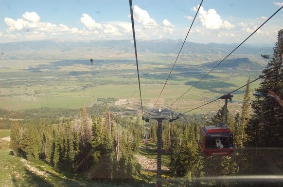
And I ended my day by scaring the bejeebies out of myself. There was this gondola, you see. It was free in the evenings. I thought it would be like the gondola at Crystal Mountain here in Washington state, which is a pleasant little ride. This was not a pleasant little ride. It turned out to be about three times as long and three times as steep, and by the time I got to the top, I was a gibbering idiot (I don’t do manmade heights, at least not ones like these). If you want to see what the view from the top looks like, click here. I left my camera in the car.

I almost couldn’t make myself ride it back down again, but a group with a baby(!) got in the gondola with me, and that happy little baby was a great distraction. Thank goodness. I’m not sure I’d have made it down sane without him!

And that was more than enough for one day.

Mirrored from Repeating History.

mmegaera: (Much Ado in Montana)

Across the wide open spaces to some rather strange places

Southern Idaho, as I’ve said before, is a desert except where it’s irrigated. I was traveling across the path taken by the Yellowstone hotspot in ancient times — if you look at a satellite view of the region, you’ll see this sort of U-shaped giant-sized ditch in the land where, over the last few million years, the hotspot made its way from northeastern Nevada/southeastern Oregon, across Idaho, and up to northwestern Wyoming, erupting periodically along the way. What it left behind was a vast trough full of volcanic rocks of various kinds.

Which isn’t necessarily a bad thing. With enough weathering and the addition of some water, it can be transformed into hellaciously fertile farmland. Think about where all those famous Idaho potatoes come from. Although Washington actually grows more potatoes than Idaho does these days — but they do it on the same types of volcanic soil. Different eruptions, though.

Anyway. I headed southeast on I-84 to the Utah state line. Once upon a time, I drove this stretch of highway in January, moving from Eugene, Oregon, to Fort Collins, Colorado, and the landscape didn’t actually look all that different from today except for the skim of dusty white snow swirling across the highway back then. This is true high desert — don’t let the signs for Salt Lake City fool you.

I left the highway at the exit labeled #26 after crossing the state line, where the sign said, rather ominously, “NO SERVICES.” But that’s where the directions for the Golden Spike National Historic Site said I was to get off, and it’s not the most isolated place on the planet I’ve ever been (see Stanley, Idaho, night before last, which doesn’t take that pride of place, either). The other sign at that exit said, rather mysteriously, “ATK.” I had no idea what ATK was, but maybe I’d get to find out.

After coming over a rise and crossing abruptly from desert to irritated farmland, then going around a few miles worth of bends in the road, I found out what ATK is. Apparently it’s where they build rockets for NASA and missiles for the Defense Department. And they’re proud of it, because out in front of this big cluster of 1960s-era-looking buildings out in the middle of absolutely nowhere was something I’ll call a sculpture garden for lack of a better term.

ATK -- a real surprise out in the Utah desert.
ATK — a real surprise out in the Utah desert.

Bemused, I parked the car and took a gander. Each one was mounted on a big metal pole, and each had its own label telling what it was.

A Minuteman missile in ATK's 'sculpture garden.'
A Minuteman missile in ATK’s ‘sculpture garden.’
A space shuttle booster rocket.

After goggling for a bit in the windy heat (it was well into the 90s that day), I got back in the car, fired up the AC again, and headed for a much older form of transportation.

Golden Spike National Historic Site, like Pompey’s Pillar (a Lewis and Clark site I visited a couple of years ago) has always sort of been on my nonexistent bucket list. It’s where the Union Pacific and the Central Pacific met in 1869, to form the first transcontinental railroad in the U.S. The event was celebrated by a bunch of dignitaries coming to this place out in the middle of the Utah desert just north of the Great Salt Lake (you can see the salt flats from a viewpoint at the site) to hammer a golden spike into the last railroad tie and ceremonially join the two railroads together.

Looking out towards the Bonneville Salt Flats and the Great Salt Lake from a viewpoint at the Golden Spike National Historic Site.

It’s an interesting place historically, and it’s also cool because the NPS keeps two replica steam locomotives on site, and runs one or the other of them daily at 1 pm for a short distance.

Steam locomotive at Golden Spike National Historic Site.
The engineer's cubby in the steam locomotive.
The engineer’s cubby in the steam locomotive.
Part of the authentic reproduction paint job.  This is a portrait of Johnny Appleseed.
Part of the authentic reproduction paint job. This is a portrait of Johnny Appleseed.

I ate a picnic lunch while waiting, after having been told by the ranger that I couldn’t bring my food indoors into the AC because they had a small mouse problem (I’m pretty sure it was the mice that were small, not the problem).

Then I got to see cutting edge transportation from the 19th century, smokestack, whistle (loud!) and all. Which was pretty damned cool (unlike the weather).

The locomotive in action.

After the demonstration, I headed east again on a backroad that thought it was a roller coaster, back down, down, down to cross I-84 again and on to the city of Logan, Utah. I hadn’t checked email in a while, and I needed groceries and gas. What ended up happening is that I got really lost trying to find the library (for email — my netbook no longer being wifi capable), but I finally made it out of town after a stop at a ranger station to make sure I was on the right road (there wasn’t a sign to be seen), where the ranger gave me a wonderful pamphlet about Logan Canyon, which was where I was headed.

And that’s how I ended up camping at Sunrise Campground in Utah, overlooking Bear Lake, up in the aspens where it was lovely and cool and the wildflowers were everywhere.

Oh, and I sold a copy of Repeating History to a couple I struck up a conversation with at the campground. Which is the first time that’s happened. I’m glad I took the print copies with me.

Mirrored from Repeating History.

Page generated Jan. 26th, 2026 09:17 am
Powered by Dreamwidth Studios